Pages
Page 1
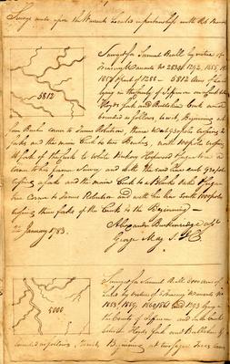
1 Surveys made upon the Warrants Located in partnership with [Rt?] Brandts [sketch map] 5812 Surveyed for Samuel Beall by virtue of Treasury Warrants no. 2834, 1292, 1655, 185[6?] 1857 & part of 1288 _ 5812 Acres of Land lying in the County of Jefferson on a Creek between Floyds fork and Bullskin Creek and bounded as follows, to wit, Beginning at four Beeches corner to James Robertson, thence west 930 poles crossing 2 forks and the main Creek to two Beeches, north 100 poles crossing A fork of the Creek to White Hickory Hoopwood & Sugar tree a corner to his former survey and with the said line east 930 poles crossing a fork and the main Creek to a Black Oak & Sugar tree corner to James Robertson and with his line south 1000 poles crossing three forks of the Creek to the Beginning - 22 January 1783 Alexander Breckenridge asst George May S.J.C. ___ [sketch map] 5000 Surveyed for Samuel Beall 5000 Acres of Land by virtue of 5 Treasury Warrants no 1853, 1859, 1860, 1861 and 1293 lying in the County of Jefferson and on a Creek between Floyds fork and Bullskin & bounded as follows, To wit, Beginning at two Sugar Trees corner
Page 2
See the Entrys upon which this Survey was made Standing at Page 20 the other end of this Book. This and the following Survey lie in a very eligible part of the County, about 30 miles from Lewisville, 12 or 15 from Bullits Lick, about 20 from Drennon's Lick & about 4 or 5 from the highest navigable part of Salt River & Floyds Fork. The land is of good quality. No interferences recollected. ___ See the Entries upon which this Survey was made standing at Page 20. the other end of this Book. see the [struck: entr] note above & apply it to this.
Page 3
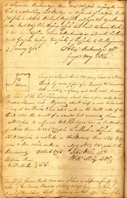
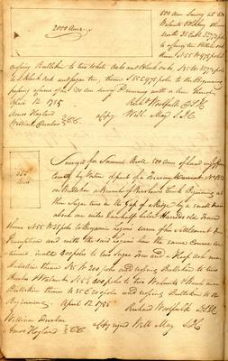
2 to Alexander Breckenridge, thence west 1067 poles crossing the main Creek to a Mulberry and Buckeye on the point of a ridge, south 750 poles to a White Hickory Hoopwood and Sugar tree by a Branch side East 1067 Poles crossing a Creek twice and the main Creek to two Sugar Saplins corner to Breckenridge and with his line north 750 poles crossing two forks of the Creek to the Beginning 19 January 1783. Alexr. Breckenridge asst. George May S.J.C. ___ [sketch map] 346 Acres Surveyed for Samuel Beall 346 Acres of Land in Nelson County by virtue of part of a Treasury Warrant no 1851 including a Spring and mill seat, known by the name of the head of Limestone about four or five miles below Hardins Summer seat, Beginning about half a mile below said Spring at two Beeches & two white oaks on the north side of [said?] Creek below the mouth of a small Gut running thence N 52 W 120 poles to a Spanish Oak and Sugar tree on the west side of a Hill thence N 38 E 277 poles to a Rock in the Creek, thence S 52 E 200 poles to a Stake in the Barrens thence S 38 W 277 poles to three white oaks on a ridge N 52 W 80 poles to the Beginning. October 6. 1786 John Helm asst. Will. May SNC William Beech Nath. Miller } CC. ___ Surveyed for Samuel Beall 2000 Acres of Land in Jefferson County by virtue of two Treasury Warrants No 1289 & 1290 lying on Bullskin a Branch of Brashears's Creek Beginning in the upper line of his
Page 4
--- This Survey was made upon a location Standing at page 19. the other end of this Book. This survey includes a good Mill Seat, the land of inferior quality, as well as the lands generally are adjacent. It lies abt. 20 miles from the Ohio & about 70 below the mouth of Salt River. There is no interference.
Page 5
3 [sketch] 2000 Acres 500 Acre Survey at two Walnuts & Hickory thence North 35 East 327 1/2 poles to a Cherry tree & White oak thence N 55 W 978 poles & crossing Bullskin to two White Oaks and Black Oaks, S 35 W 327 1/2 poles to a Black Oak and Sugar tree, thence S 55 E 978 poles to the Beginning passing a Corner of his 500 Acre Survey & running with a line thereof April 12. 1785 Amos Hogland William Dunbar } C.C. Richd Woolfolk D.S.J.C. a Copy Will. May S.J.C.
___ [sketch] 500 Acres Surveyed for Samuel Beall 500 Acres of Land in Jefferson County by Virtue of part of a Treasury Warrant No 1854 on Bullskin a Branch of Brashears Creek Beginning at three Sugar trees in the Gap of a Ridge by a small drain about one mile & an half below Harrods old Trace thence N 55 W 28 poles to Benjamin Logan's corner of his Settlement & Preemption and with the said Logan's line the same course continued, in all 400 poles to two Sugar Trees and a Hoop Ash near Bullskin thence S 35 W 200 poles and crossing Bullskin to two Beeches & Walnut S 55 E 400 poles to two Walnuts & Beech near Bullskin thence N 35 E 200 poles and crossing Bullskin to the Beginning. April 12 1785 William Dunbar Amos Hogland } C.C. Richard Woolfolk D.S.J.C. a Copy signed Will May S.J.C.