Pages
Page 16
Good Land and about 12 miles S.E. of Bards Town - in a a good neighbourhood & supposed free of any interference. The Rolling Fork is navigable as high up as this & abounds with fine fish.
--- Very rich Land with fine Springs on it, called the Cyprus Springs : Jacob Myers' has a 400 acre Preemption in this Tract including the said Springs. It is a few miles below Vienna at the Falls of Green River. There is 2000 Acres of Land in this survey exclusive of Myers 400 Acres * assee. of Wm. Finnie.
Page 17
11 South 50 E 850 poles to two large Red oaks and Hickory, thence N 40 E 130 poles to an Elm mulberry and White oak in Chilton's line 17 poles from his South West Corner thence N 10 W with a line thereof 491 Poles to a Red Oak poplar and Hickory corner to said Chilton on the Bank of Panther Creek thence down the Meanders of the said Creek to its mouth and up Green River to the Beginning, which said Courses include one Survey in the name of Jacob Myers of 400 Acres on said River which Survey is prior to the said John Mays and not claimed by him and 2000 Acres of unappropriated Lands. December 16. 1784. John Handley asst. Will May S.J.C.
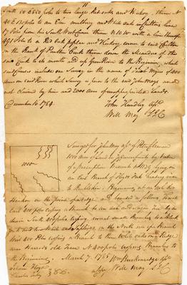
--- [sketch map] 1000 Surveyed for John May assee. of Peter Coleman 1000 Acres of Land in Jefferson County by virtue of a preemption warrant no 1139 lying on an East Branch of Floyds Fork heading near to Bullskin, Beginning at an ash & Hickory on the point of a ridge and bounded as follows, To wit East 400 poles crossing a Branch to an ash and Sugar Tree by a drain South 400 poles crossing several small Branches to a Black oak and two White oak Saplings on the North side of a Branch West 400 Poles crossing a Branch to three white oaks on a Ridge near Harrods old Trace N 400 poles crossing Branches to the Beginning. March 7. 1785 Wm Breckenridge asst. a Copy Will May S.J.C. Isham Floyd Charles Tuley } C.C.
Page 19
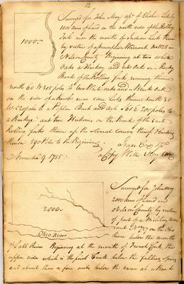
12 [sketch map] 1000 Rolling Fork Surveyed for John May assee. of Elisha Likely 1000 Acres of Land on the north side of the Rolling Fork near the mouth of Indian Lick Run by virtue of a preemption warrant no 1128 in Nelson County Beginning at two white Oaks a Hickory and red oak on a Rocky Bank of the Rolling fork running thence north 60 W 305 poles to two White oaks and a Black oak on the side of a Knob near some Licks thence south 30 W 520 poles to a Poplar Beech and Ash S 60 E 200 poles to a Buckeye and two Hickories on the Bank of the said Rolling fork thence up the several courses thereof & binding thereon 590 Poles to the Beginning. November 9. 1785 Isaac Cox asst. A Copy Will May [SNC?]
--- [sketch map] 2000 Ohio River Surveyed for John May 2000 Acres of Land in Nelson County by virtue of a part of a Military warrant No 737 on the Ohio River below the mouth of Salt River Beginning at tbe mouth of French Creek, the upper side which is the first Creek below the falling spring and about three or four miles below the same at a Beech
Page 20
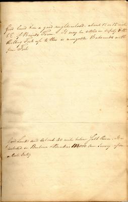
Good land & in a good neighbourhood - about 12 or 15 miles S.E. of Bairds Town. It may be settled in safety & the Rolling Fork up to this is navigable & abounds with fine Fish
--- Good Land and about 40 miles below Salt River. It is included in Barbour & Banks's 113,000 Acre Survey upon a late Entry