Pages
Page 11
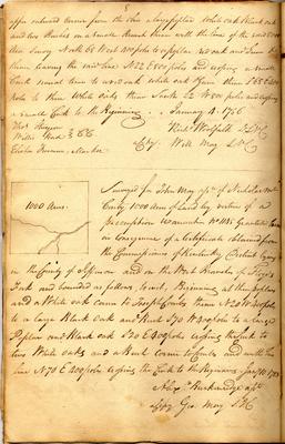
8 upper outward corner from the Ohio a large poplar White oak Black oak and two Beeches on a small Branch thence with the line of the said 8000 Acre Survey North 68 West 400 poles to a poplar red oak and Gum & thence leaving the said line N 22 E 800 poles and crossing a small Creek several times to a red oak and white oak & Gum thence S 68 E 400 poles to three white oaks thence South 22 W 800 poles and crossing a small Creek to the Beginning. January 4. 1786 Thos. Sturgeon Willis Hurd } C.C. Elisha Freeman, Marker Richd Woolfolk D.S.N.C. a Copy: Will May S.N.C.
--- [sketch map] 1000 Acres Surveyed for John May assee. of Nicholas McCarty 1000 Acres of Land by virtue of a preemption warrant no 1145 Granted him in Consequence of a Certificate obtained from the Commissioners of Kentucky District lying in the County of Jefferson and on the West Branches of Floyds Fork and bounded as follows, to wit, Beginning at three poplars and a White oak corner to Joseph Combs thence N 20 W 400 poles to a large Black Oak and Beech S 70 W 400 poles to a large Poplar and Black oak S 20 E 400 poles crossing the Creek to two White oaks and a Beech corner to Combs and with his line N 70 E 400 poles crossing the Creek to the Beginning. Jany 10 1783 Alexr. Breckenridge asst. a Copy Geo. May S.J.C.
Page 13
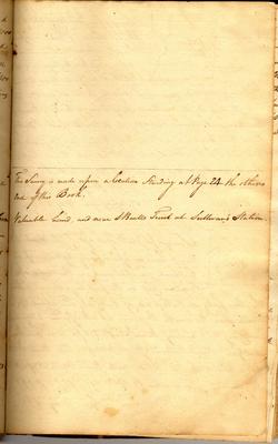
9 [sketch map] 1000 Acres Surveyed for John May asee. of John Warford 1000 acres of Land in Jefferson County on preemption warrant no 1153 on Brashear's Creek beginning at an Ash Beech and Gum corner to said Warford's Settlement running S 346 poles to two Sugar trees and Ash standing 10 poles on the south of a large Creek a Branch of Brashear's Creek, thence East 374 poles to two Walnuts & Hickory thence North 600 poles to a Sugar Tree poplar and Dogwood thence West 121 Poles to a Black oak and White oak, thence South 254 Poles to two Sugar Trees thence West 253 poles to the Beginning. December 13. 1783 Wm Pope D.S.J.C. a Copy Geo. May S.J.C.
--- [sketch map] 400 Surveyed for John Warford assee. of John Hunt 400 Acres of Land in Jefferson County by virtue of a Certificate for settlement on the waters of Brashear's Creek on the first large Branch below the three forks on the East side of said Creek and about 2 1/2 or 3 miles above the mouth Beginning at a Hoopwood honey Locust and Cherry tree running thence South 254 po. to an Ash Beech and Gum thence East 253 po: to two Sugar trees thence N 254 po. a Black oak and White oak thence West 253 po. to the Beginning. December 13. 1783. Wm Pope D.S.J.C. Geo. May S.J.C.
Page 15
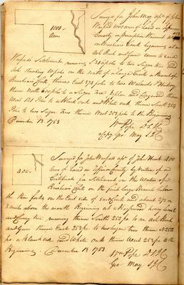
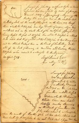
10 [sketch map] 400 Surveyed for John May and Conrad Oyler as Tenants in Common 400 Acres of Land by Virtue of a preemption warrant No 1147 in Jefferson County - Beginning at a Hickory Elm and Sugar Tree on the South Bank of the Rolling Fork at the mouth of Clear Creek on the lower side thereof thence South 60 W 160 poles to a large Double Sycamore, Sugar Tree and White ash on the South Bank of the north fork of Clear Creek having crossed the fork at 103 poles then N 30 W 300 poles to a Black Oak white oak & Dogwood No 60 E 214 poles to two Honey Locust and two Black Walnut trees on the Bank of the Rolling Fork and up the Fork following its meanders and binding thereon 310 poles when reduced to a straight to the Beginning - 20 April 1784. Joseph Barnet asst. Geo: May S.J.C.
--- [sketch map] 2000 Green River Surveyed for John May 2000 Acres of Land in Jefferson County by virtue of a Military Warrant * No 301 in the forks between Green River and Panther Creek William Smith & William Elliott Chain men Isaiah Radcliff marker Beginning on the Bank of Green River 510 poles when reduced to a straight line above the mouth of Panther Creek at two Ashes & White oak thence South 29 W 200 poles to an ash White Oak & Sugar Tree, thence