Pages
Page 21
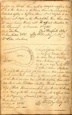
13 two Sugar Trees and Ash, thence south 30 W 400 poles and Crossing French Creek to three Hickories in the Plains thence S 60 E 800 poles to a White Oak Sapling in the plains thence N 30 E 360 poles to two Sycamores and Maple on the Bank of Ohio River thence down the same binding thereon with the different Meanders to the Beginning. November 3rd 1785. Reuben Thornton William Theckston } C.C. Wm Patton, Marker Richd Woofalk D.S.N.C. a Copy Will May S.N.C.
--- [sketch map] Island Island 3000 Ohio River Surveyed for John May 3000 acres of Land in Nelson County 2500 acres thereof on two Military Warrants No 304 & 297 and 500 acres the Residue on part of a Military Warrant no 298 - on the Ohio River on the Round Bottom or Big Bent - Beginning on the lower point of the first Island that is below the mouth of Salt River and known by the name of the two Islands at two Beeches and Sugar tree on the Bank of Ohio, thence S 10 W 264 Poles to a Black Walnut Mulberry and Ash under a high Clift of Rocks and near a remarkable large Rock on the River bank thence up the Ohio binding thereon with its different meanders to the Beginning. November 9. 1785. Richd Woolfalk D.S.N.C. a Copy Will May S.N.C. Reuben Thornton Wm Thecktston } C.C. Wm Patton, Marker
Page 23
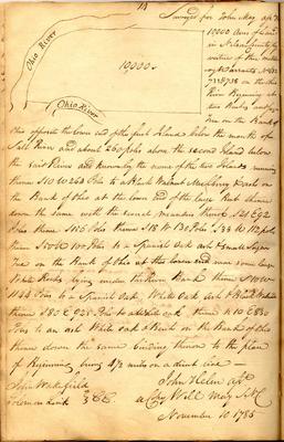
14 [sketch map] Ohio River Ohio River 10,000 Surveyed for John May assee. [illegible] 10,000 Acres of Land in Nelson County by virtue of three military Warrants No 632 733 & 738 on the Ohio River Beginning at two beeches and Sugar Tree on the Bank of Ohio opposite the lower end of the first Island below the mouth of Salt River and about 260 poles above the second Island below the said River and known by the name of the two Islands running thence S 10 W 264 Poles to a Black Walnut Mulberry & ash on the Bank of Ohio at the lower end of the large Bent thence down the same with the several meanders thereof S 21 E 92 Poles thence S 156 Poles thence S 18 W 130 Poles S 33 W 112 poles thence S 50 W 100 Poles to a Spanish oak ash & small Sugar tree on the Bank of Ohio [struck: at the lower end] near some large White Rocks lying under the River Bank thence S 10 W 1144 Poles to a Spanish Oak, White Oak, Ash & Black Walnut thence S 80 E 925 Poles to a White oak thence N 10 E 830 Poles to an ash White oak & Beech on the Bank of Ohio thence down the same binding thereon to the place of Beginning being 4 1/2 Miles on a direct line - John Wakefield Solomon Link } C.C. John Helm asst. a Copy Will May S.N.C. November 10 1785
Page 25
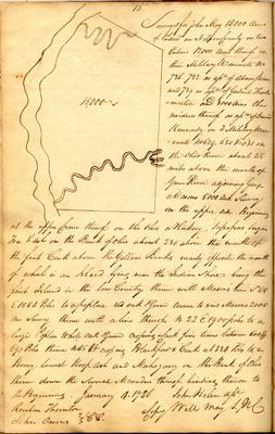
15 [sketch map] 15,000 Surveyed for John May 15,000 Acres of Land in Nelson County in two Entries 12,000 Acres thereof on three Military Warrants no 736. 732 as assee. of Adam Steven and 739 as assee. of Gabriel Thockmorton and 3000 Acres the residue thereof as assee. of David Kennady on 3 Military Warrants no 629, 630 & 631 on the Ohio River about 28 miles above the mouth of Green River adjoining George Masons 8000 Acre Survey on the upper side Beginning at the upper Corner thereof on the Ohio a Hickory, Sassafras, Sugar Tree & Ash on the Bank of Ohio about 230 above the mouth of the first Creek above the Yellow Banks nearly opposite the mouth of which is an Island lying near the Indian shore being the first Island in the low Country thence with Mason's line S 68 E 1084 Poles to a poplar red oak & Gum corner to said Masons 2000 acre Survey thence with a line thereof N 22 E 1900 poles to a large Poplar White Oak & Gum crossing a Creek five times between 600 & 690 Poles thence N 45 W crossing Blankfords Creek at 334 Poles to a Honey Locust Hoop Ash and Mahogany on the Bank of Ohio thence down the several meanders thereof binding thereon to the Beginning. January 4. 1786 John Helm asst. a Copy Will May S.N.C. Reuben Thornton John Owens } CC.