Pages

Page 6
This Survey was made upon a Location Standing at Page 20. the other end of this Book The same note that is made on the 5812 & 5000 at P1, will nearly apply to this, it lying in the same neighbourhood with the above mentioned 5812 & 5000.
___ This Survey was made upon a Location of Brandts's standing at page the other end of this Book, but was given to John Floyd in lieu of other Locations for Brandts. See the note on the above Survey, which applies to this also
Page 7
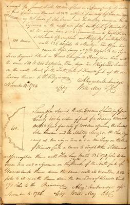
4 [sketch map] 500 Acres Surveyed for Samuel Beall 500 acres of Land in Jefferson County by virtue of part of a Treasury Warrant No 1852 and part of an entry of 3000 acres adjoining the Lands of John Cowan and the Military Surveys on the Ohio beginning on the north side of the south fork of Harrods Creek at two Sugar Trees and a Sycamore corner to Joseph Hite's Settlement & preemption and Philip Ross with Ross's line north 53 E 400 poles to a Buckeye, Elm & Sugar Tree corner to Ross's Survey N 37 W 362 poles to two Sugar Trees Dogwood & Beech in David Crawfords Preemption line with the same S 14 W 460 to a Poplar, Elm, Sugar Tree & [struck: Hoopwood] Ironwood on the north Bank of the South fork of Harrods Creek up the same binding thereon to the Beginning. November 14th: 1784 Alexander Breckenridge a copy Will May S.J.C.
___ [sketch map] 600 Surveyed for Samuel Beall 600 acres of Land in Jefferson County 500 by virtue of part of a Treasury Warrant No 1853 & part of an entry of 3000 acres adjoining the Lands of John Cowan and the Military Surveys on the Ohio, Beginning at two Sugar Trees and a Mulberry on the Bank of Harrods Creek a corner to Joseph Hites Settlement and preemption thence with Hites line north 53 E 494 poles to two Sugar Trees and a Sycamore on the [inserted above: South] Bank of the South fork of Harrods Creek thence down the same with its meanders 402 poles to its mouth thence down the meanders of Harrods Creek 571 Poles to the Beginning November 4. 1784. Alexr. Breckenridge asst a Copy Will May S.J.C.
Page 8
This is part of a Location made the 14 March 1781 see page 19 the other end of this Book This land lies abt. 12 or 15 miles from Lewisville and abt. 4 or 5 from the Ohio. The Harrods Creek & Beargrass Lands form the most eligible part of the District. No interference recollected
___ This Survey is made upon part of an entry of 3000 acres made the 14 March 1781 see page 19 at the other end of this Book.
apply the above note to this also
Page 9
7 Surveys made upon Locations in which Samuel Beall & John May are Interested, to wit, ---
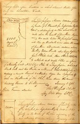
[sketch map]Ohio River A 8000 acres of Land Surveyed for George Mason 8000 acres of Land by virtue of a Warrant for Importation Rights No 5 in Nelson County on Ohio about 20 or 25 miles above the mouth of Gum River, Beginning two miles below the first Creek running into Ohio on the South side above the mouth of Gum River and a small distance above the Big Yellow Banks at a large poplar Gum & White Oak, thence N 68 E 1484 poles to a Black Oak Maple & Elm in a piece of Marshy Land N 22 E 890 Poles to a large poplar, white oak Black Oak and two Beeches on a Branch N 68 W 1484 poles and crossing a small Branch to a Hickory Sugar Tree Sassafras & Ash on the Bank of the Ohio, thence down the same binding thereon to the Beginning. January 3. 1786 Elisha Freeman Marker Richd Woolfolk D.S.N.C. a Copy Will May S.N.C.
--- [sketch map] A B 2000 Surveyed for George Mason 2000 acres of Land by virtue of a Warrant for Importation Rights No 10 in Nelson County on the waters of the Ohio adjoining of the said Mason's 8000 acre Survey Beginning at his
Page 10
This and the next 2000 recd. of Mason for 10,000 acres of John Smith's on Panther Creek. see the entry at page 12. other end of this Book. First rate Land. No interference recollected
___ This and the above 8000 was recd. of Mason for 10000 acres of John Smiths on Panther Creek - see the entry at Page 12. other end of this Book First rate land. No interference recollected