Pages

Page 37
20 Beginning at a Maple on the Bank of the River at the mouth of a Creek emptying in about 12 miles above the mouth of Salt River and running thence South 35° E 410 poles to three Small Beeches S 29° W 400 Poles to 4 Beeches N 61° W 250 Poles to two Hoopwoods and Beech on the Bank of the River and up the same with the Meanders N 78 Poles N 5 E 91 Poles N 15° E 100 poles N 23 E 201 Poles N 30 E 138 Poles to the Beginning. October 26. 1786 Ro. Breckenridge D.S. a Copy Alexr. Breckenridge S.J.C.
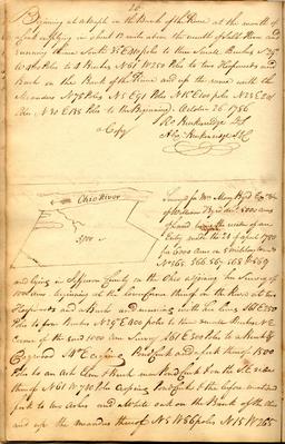
--- [sketch map] Ohio River 5,000 Surveyed for Mrs. Mary Byrd Exrx. &c. of William Byrd decd. 5000 acres of Land being the residue of an Entry made the 24 of April 1780 for 6000 acres on 5 military warrts. No 565, 566_567_568 & 569 and lying in Jefferson County on the Ohio adjoining her survey of 1000 acres _ beginning at the lower corner thereof on the River at two Hoopwoods and a Beech and running with her lines S 61 E 250 Poles to four Beeches N 29° E 400 poles to three small Beeches NE corner of the said 1000 acre survey S 61 E 300 Poles to a Beech & Dogwood S 4° E crossing Pond Creek and a fork thereof 1500 Poles to an Ash Elm & Beech near Pond Creek & on the S.E. side thereof N 61 W 740 Poles crossing Pond Creek & the before mentioned fork to two ashes and a White oak on the Bank of the Ohio and up the meanders thereof N 5 W 86 poles N 15 W 265
Page 38
21 poles N 10 W 140 Poles N 5 W 336 poles North 218 Poles to the Beginning. 28 October 1786. Ro: Breckenridge DS. a Copy Alexr. Breckenridge S.J.C.
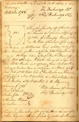
--- [sketch map] D C 1000 A B Surveyed for John May assee. of Cornelius Getter one thousand acres of Land in Jefferson County by virtue of a Preemption Warrant no 1129 on the Waters of Brashears's Creek emptying into the same on the East side thereof including sundry of the Head Branches of a Run and Cornelius Getters Improvement Beginning on the Ridge between Meadow Run & a Branch of Clear Creek that Abraham Whitaker lives on at a Sugar Tree Elm and two Beeches and extending thence S 10 E 400 Poles crossing a Meadow Run in said Course to a Beech Ash & Red Oak N 80 E 400 Poles to three Beeches near a Drain of [Greess?] Creek N 10 W 400 Poles to a Black Walnut Beech and Hickory S 80 W 400 Poles to the Beginning. January 9. 1786 James McQuaid Cornelius Getter _ } C.C. a Copy Abraham Whitaker Marker } Will: Shannon asst. surveyor Alexr Breckenridge S.J.C.
---- Surveyed for John May assrr. of John Hews who was assee. of Arthur Ingram 1000 acres of Land by virtue of a Preemption
Page 40
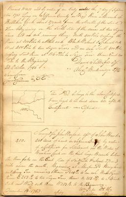
22 Warrant No 1151 and by virtue of an Entry dated the 7 day of September 1781 Lying in Jefferson County on Fox Run a Branch of Bullskin Creek about 2 1/2 miles from the Mouth of the said Run Beginning on the south side of the same at two sugar Trees and an ash running thence North 400 poles crossing the Run at 300 Poles to a White oak Black Walnut & Spanish oak West 400 Poles to two Sugar Trees and an ash South 400 Poles crossing said Run at 156 Poles to a Sugar Tree thence East 400 Poles to the Beginning 23 October 1786 James Coran Conrad Coleman } C.C. David Standiford D.S. Alexr. Breckenridge S.J.C.
--- sketch map] 1000 This Plot belongs to the above Certificate & was forgot to be laid down till after the Certificate was copied
--- [sketch map] 400 Surveyed for John Warford assee. of John Hunt 400 acres of land in Jefferson County by virtue of a Certificate for Settlement on the Waters of Brashears Creek on the first large Branch below the three forks on the East side of said Creek & about 2 1/2 or 3 miles above the mouth, Beginning at a Hoopwood Honey locust and Cherry Tree running thence S 254 Po: to an ash Beech & Gum thence E 253 Po: to two Sugar Trees, thence N 254 Po: to a Black Oak and White oak thence W 253 Po. to the Beginning. December 13th: 1783. Wm Pope D.S.J.C. a Copy G. May S.J.C.