Pages
23 (V.1)
23
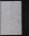
regarding it were explained to Lord Auckland who was at that time Governor General, with a recommendation that Government should authorize the disbursement of a few thousand rupees for an examination of the [Khadin ?] to prove the practicability or not of overcoming the difficulties which were supposed to exist in that region. His Lordship having approved of this measure and having directed me to carry on the enquiry, I proceeded to [Kundwar ?] and commenced operating early in the month of December 1839. My design for carrying out these operations will be best explained by a diagram, and by a detail of the data on which my views were founded -
DIAG: 1
The line of levels which had been taken by me in 1836 is shown by the dotted line; it commenced from the surface of the water in the Bangunga near the village of Badshahpoor, which is situated 23 miles south of Kundwar - from the point A the levels

24 (V.1)
24
levels ran for a distance of 40 miles (infringing on the head of the east Kalli Nuddi at B, or at the village of Untwarra marked in the above Diagram) to the point C on the west Kalli Nuddi; it was at the point C immediately under the village of Rampoor, that the head of Muhummud Aboo Khan's canal was situated, and when the dam proposed by Captain Debude was to have been built. The following results were obtained from the above line of levels The Point A 83.225 feet below D A 23.19 feet below B A 12.69 feet below C A 30 feet below the land on which the village of Rampoor stands. In other words on a line of [10 ?] miles, or from the surface of the river near the village of Badshahpoor, to the surface of the west Kalli Nuddi at Rampoor the fall is only 12.66 feet: and to the surface of the high land on which Rampoor stands there is an actual rise of 30 feet. From the point A to D, a distance of 10 1/2 miles, the land is almost entirely on one level for the distance of 9 miles; at this point it rises suddenly until it gains an elevation of 83.225 feet near the village of [Kumbhera ?] at D; its slope onwards towards Rampoor may be estimated at 2 3/4 feet per mile. The debouche of the Ganges into the plains lies at least 25 miles lower on a latitudinal line than that of the Sumna. The eastern Sumna canal which leaves the Sumna at the point of debouche from the hills, has opposite the town of

25 (V.1)
25
of [Sahaumpoor ?] (which is nearly on the same parallel as Kundwar) lost 300 feet of level; the eastern Sumna canal at the village of [Bynswal ?], which is similarly situated to [Bebra ?], is 125 feet below Sahaumpoor. Taking therefore the known barometrical heights of Kundwar and Sahaumpoor, and reducing the canal levels accordingly, the following results were arrived at: Above the sea Above the sea Sahaumpoor 1013 Kundwar 1024 Bynswal - on the eastern Sumna 888 Bebra 888 ? canal Total fall from Kundwar at Bebra feet 136 I assumed, therefore, that the village of Bebra was not very far different in barometrical height to that of Bynswal, and that as by taking a circuitous route from Kundwar to Bebra, which could hardly under any circumstances exceed 50 miles in length, the object of my survey was evidently attainable even were the land at Bebra much more elevated than I had assumed it to be. the line of operations for the survey therefore, was sufficiently clear, it resolved itself into a simple examination of the ground between Kundwar, and the westernly portion of the [Khadir ?] both above and below [Roorkee ?], and, to use the words of my original report to the Government, "the only "objections (supposing that my as"sumed height of Bebra is correct) "to the project, depend upon the state "of the country's surface in that "direction; if a connected ridge can be
26 (V.1)
26
"be discoverd only broken by the "Escape of the Solani, this River "would I Imagine offer no un "conquerable imprediment to a "Canal"
By feeling my way along the country westward of nurdwar[?] and embracing the westerly potion of the Khauir[?} by circles of levels in numerous sweeps both above and below the ree line upon which the canal would take its course this true line exhibited itself on tow direction; the first, extending very much to the west by which the line of canal bed would con= tinue in soil: the second, a more direct line crossing the valley of the Solani River by an aqueduct.. The one had a very extended circuit, stretching far to the west into the high land which forms the heads of the Solani River and therby coming in contact with a great quatity of mountain drainage ; the other was more diarectly avoiding the forests and drainage which the first line had to contend againt, it ne= =cessitated however the crossing of the valley on the high levels, and the construction of an aqueduct, the cost of which was great.
After completing the survey of the Khallir tract, and satisfying myself of its being suited to the reqired purposes, I contuinued a series of levels both longitudinal and transverse to a near [?]. I had during my survey at Nurdwar [?] measured the discharge of the Ganges River, the supply of which in the months of December and January
27 (V.1)
December and January was equal to 8000 cubic feet xxxsecond?, and therefore capable of providing for any demands that we might make upon it; I had in my progress down the country observed that material of all sorts could be pro= cured without much difficulty; and it appeared to me that in submitting a project to government, it was desirable to produce one on a minimum scale, in which the cost of the works through the khadi would be met by a sufficiently remunerating return on the Irri= =gation which lay below that tract the estimate in fact which I pro= =posed to submit was intended to show the smallest amount at which a canal could be made with advantage; and having explained the facilities that ex= =isted both in material and in a supply of water, together with the means of carrying that sup= =ply over the difficulties of the Ganges khadir, I left it to the Government to determine whether by the construction of a larger and more spacious channel, the extent to which the water of the Ganges could be applied to irri= =gation i the [?] might not be taken the fullest advantage of my report and Estimate on the Ganges khadir is dated 30th June 1820, the amount of the latter was company's Rupees 10,00,113 The supplemental report on the prolongation of the Canal down the Doub's[?] dated 15.th August 1820 and the amount of the Estimate which accompanied it was 15,91,045 Total Companys Rupees 25,91,158