Pages
Page 1
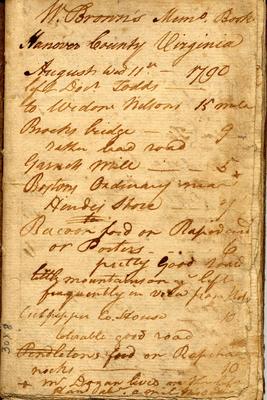
[William Brown|W. Brown]]'s Memo Book Hanover County Virginia August Wed 11th - 1790 left Docr Todds - to Widow Nelson 5 miles Brooks bridge - 9
rather bad road Garnets Mill - - 5 Bostons Ordinary near Hindes Store - Racoon ford or [Rapidard?] or Porters - 6 pretty Good road little mountains on ye left frequently in vela from [?] Culpepper Co. House - 10 tolerable good road Pendletons ford on [Rapi...?] rocks - 10 + mr Dogan lives on the left Hand [abr?] a mile [? ?]
Page 2
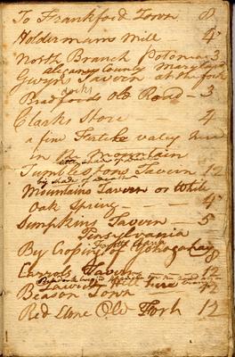
To Frankford Town 8 Holdermans Mill - 4 North Branch Potomac 3 aliganey County Maryland Gwyns Tavern at the fork Bradfords old Road - 3 Clarks Store - - 4 a fine Fertile valey here in the mountain Tumblestons Tavern 12 big shades of Death Mountains Tavern or White Oak Spring - - - 4 Sumpkins Tavern - 5 Pensyvania Fayette County By Crossing of Yohagahay 8 Carrolls Tavern - - - 12 Bradock [buried?] 4 miles on the road at [? ?] Beason Town - 12 Red Stone Old Fork 12
Page 3
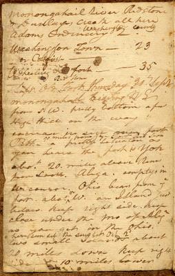
Monongahail river Redstone & Dunlaps Creek all here Washington County Adams Ordinary 2 Washington Town - 23 or Catfish - Wheeling on fork - - 35 Red Stone
Left Old Fork thursday 30th Sept, monongahail bearing N E from S W. pretty bottom a few High Hills on the way
encrease in sign [going?] fort 90 miles from ye Fort Red Stone [?] - a pretty situation as you leave the fort is [Yoh? York?] abot 20 miles abov Rams from [Lock?]. Alega. emptys in [the consor?] Ohio bears from ye fort. abot ^N W. an Island just below. keep right side. keep close under the [?] of [Alega?] as you get in the Ohio. here sun set the sun set Oct 2d two small Islands about 20 miles down keep right side - 10 miles lower
Page 4
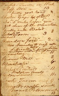
Douglass Tavern on Week =iffs Store - 13 pretty good road Chester Gap top of Red 8 abot 5 miles before you get clear of the mountain pretty well Waterd [Lehan?] Town - 3 Thanadore ford - 2
two branches to cross rather a difficult ^way a [few ?] below a fine stream water abt 14 miles from townStevensburg - - - 10 Browns Mill - - 2 Winchester - - 6 Gasper Rinkers - 11 Hamshire County Widow Lewiss - 11 Crocks Tavern - 9 Reynolds on the south Branch Potonmach 13
Page 5
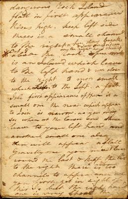
dangerous rock Island flatt in first appearance Rises high. keep left side there is a small channel to the right & here day breaks saw an Indian on the right hand channel
# Oct 3d above the rock a few miles is an Island which leaves to the left hand & runs close to the right 3 more small which Leave to the Left. a forth Isle first appearance of them is a small one the next which appear to Join is narrow. as you may see when at the lower and these leave to your left hand and another small one also these will appear a [flatt?] Gravelly one you must leave round the last & keep the last to the right there is too channels to appear and when you first get in sight of this I. but the right hand one is very [short? steep?] the