Pages That Mention alto luogho
Vat.lat.7612 Place names identified
23r
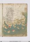
P. 45 Rodi euna isoletta cheschostata daterra ferma qualche miglia venti edacientocinquanta esuogirata equivi volgie illito adaltri venti insino atenedon diritto ghuatta quella chostiera miglia quatroccientoventi amaestralle ver tramontana aquarta secondo chessivede insulla charta
Vero e chedigrani gholfi aquesto lito chentram fraterra edigrani capi imare ede daassai ebuoni porti fornito dovelnavilio sechuro possa faare [corr. fire?] fraterra abuone ville eforte sito etemperto esano perabitare esta diritto chonitalia efrancia equesta giente porta bensuo lancia
Quivi alto luogho presso alameta deldetto fregho adeffesa vicina lesmirre foya lardemiti inqua tutti sonpoi ingholfi dimarina poi quasi alfine fu lagram citta ditroya dove fu lagram rovina del superbo ylion chefu conbusto onde fu laprogenia daghusto
[Image: Bottom and right margins, a map of the eastern coast of Anatolia with bluish-green water (label: PARTE DARCHIPELAGO) and brown/gray brush strokes for the land. Islands are labelled in red, (label: Tenedon), (label: Metellino), (label: famo), (label: lango), and (label: Rodi), and cities on the mainland in red: (label: Troya), (label: landermit), (label: Messa), (label: Alto luogo). The islands of Metellino and Rhodes are decorated with red brushstrokes, but Rhodes has a white penwork Maltese cross instead of a text label. The city of Troy is marked with dramatic flames surrounding a large harbor.]