Pages That Mention tenedon
Kenneth Spencer Research Library, Pryce MS P4 Place Names Identified

Page 46
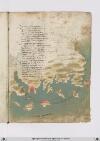
P. 46 ROde e/ una ysola che e/ scostata Da terra ferma qualche miglia vencti E da ciento cinquanta e sua girata Equivi voglie illito ad altri venti Ensino atenedon dricto guata Quella costiera miglia quatro centi Ad maestral ver tramontana ad quarta Secondo che si vede insula carta Vero e/ che di grangolfi aquesto lito Chentranfra terra e/ di gran capi in mare Et e/ dassai et bon porti fornito Dovel navili sicuro possa store Fra terre et bon ville e forte sito Etemperato e/ sano per habitare Esta dricta con ytalia et francia Et quella gente porta ben sua lancia Quivi e/ alto luogho pressa altameta Del decto frego ad epheso vicina Le smirne fuya elanderimicti inqua Tuctesonpoi in golfi dimarina Poi quasi alfine fu la grancipta Di troya dove fo la gran royna Del soperbo ylion che fo conbustio Onde fula progenie dagusto
[Image: Lower margin, a portolan-style map illustration showing the Mediterranean coast of Turkey. Islands or ports, left to right, are: Lemnos (label: iambro), Tenedos (label: tenedo), Mitilini (label: metelmo) on Lesbos, Chios (label: assio.), Samos (label: xamo.), Kos (label: Lango), and Rhodes (label: rodi.). To the right of the Dardanelles (label: [elis?]ponto), the cities/ports tentatively identified on the Turkish mainland, left to right, are: [?] (label: ruto?), Troy (label: troia), Edremit (label: landermitti.), [Foça?] (label: foia.), İzmir (label: lasmirne.), Selçuk (label: alto loro), and Milas (label: messi).
Vat.lat.7612 Place names identified
23r
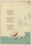
P. 45 Rodi euna isoletta cheschostata daterra ferma qualche miglia venti edacientocinquanta esuogirata equivi volgie illito adaltri venti insino atenedon diritto ghuatta quella chostiera miglia quatroccientoventi amaestralle ver tramontana aquarta secondo chessivede insulla charta
Vero e chedigrani gholfi aquesto lito chentram fraterra edigrani capi imare ede daassai ebuoni porti fornito dovelnavilio sechuro possa faare [corr. fire?] fraterra abuone ville eforte sito etemperto esano perabitare esta diritto chonitalia efrancia equesta giente porta bensuo lancia
Quivi alto luogho presso alameta deldetto fregho adeffesa vicina lesmirre foya lardemiti inqua tutti sonpoi ingholfi dimarina poi quasi alfine fu lagram citta ditroya dove fu lagram rovina del superbo ylion chefu conbusto onde fu laprogenia daghusto
[Image: Bottom and right margins, a map of the eastern coast of Anatolia with bluish-green water (label: PARTE DARCHIPELAGO) and brown/gray brush strokes for the land. Islands are labelled in red, (label: Tenedon), (label: Metellino), (label: famo), (label: lango), and (label: Rodi), and cities on the mainland in red: (label: Troya), (label: landermit), (label: Messa), (label: Alto luogo). The islands of Metellino and Rhodes are decorated with red brushstrokes, but Rhodes has a white penwork Maltese cross instead of a text label. The city of Troy is marked with dramatic flames surrounding a large harbor.]
23v
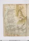
P. 46 Quatro isolette diciento insettanta miglia digiro ongniuna epresso allito ameno diventi esono dilungi ottanta luna dalaltra perdiritto rito sondopo rodi ellaprima sichanta langho epoi laltra chetiene elsuo sito dichontro adalto luogho edetta samo scio elaltra emettelino lachiamo
Orentra nellostretto aturchia checircha asette miglia largho inboccha inverso greco esol perquella via eldetto mar nelmar maggiore rinboccha eciento ottanta miglia parchessia peldetto vento perfino laove tocha lemura dellamperial ciptta chensulaltra piu stretta boccha sta
La citta daveo sta nelchominciare dallamandestra dentro aldetto stretto onde verso aquilone arighuardare ghalipoli cipta vedirispetto epoi piusu comincia aralarchare ebensesanta miglia adtragietto dadraschilo chepur daman destra fino allaboccha stretta dasinestra
[Image: Upper right margin, a map of the Dardanelles with the sea in grayish-green and lands in brown wash, with place names labelled in red, from (label: Tenedon) at the bottom through the (label: Arcipelago) to the (label: Mare di Tribisonda), i.e. the Black Sea; the city of (label: Salogi) on the mainland at left.]
Yale: Beinecke MS 946 Place Names Identified

Page 47
P. 47 Rodi e una isoletta che e scostata da terra ferma qualche miglia venti insino a tenedon diritto guata et quivi volge il lito ad altri venti e a cento cinquanta e sua girata quella costiera miglia quatrocento a maestral ver tramontana quarta secondo che si vede in sulla carta
Vero e/ di gran golfi a questo lito ch'entra fra terra et di gram capi in mare et e d'assai buon porti fornito dove il navil sicuro possa stare fra terra a buone ville et forte sito e temperato et sano per abitare e sta diritta con italia e francia et quella gente porta ben suo lancia.
Quivi e/ alto luogo presso alla meta del detto frego ad effaso vicina le smirre foia et landermiti in qua tutti son poi in golfi di marina poi quasi al fine fu la gran cipta di troia dove fu la gran ruina del superbo ilion che fu combusto onde fu la progenie d'agusto
BnF. Bibliothèque de l'Arsenal. Ms-8536
77r
p. 44/ f. 77r
¶ Rodi -e- una insuleta che s'acosta Da terra firma qualche miglia cento E ducento cinquanta e sua girata E qui volgie il lito ad altri venti Insino at'tenedon drito guata Quella costiera miglia quatrocento A maestrale ver tramontana at quarta Secundo che si vede in su la carta.
¶ Ver e che di gran golfi ha questo litto Ch'entran fra terra e di gran capi in mare Ed assai e di bon porti fornito Dove 'l navil sicur possa stare Fra terra ha bone ville e forte sito E temperato e sano per habitare Esta dricta anchona in'talia e francia E quella gente porta ben suo lancia
¶ Qui e alto luogo e presso ala mita [corr.: "e" superscript above "i" for "meta"] Del dicto frego ad ephesso vicina Le smire foia et l'andemitri in qua Tute sum poi in golfi de Marina Poi quasi al fine fu la gran cita Di troia dove fu la gran ruina Del superbo illion che fu combusto Unde fu la progenia d'augusto
[image, bas de page: Map of of the Aegean coastline around Troy. Ocean painted aquamarine with wave pattern in grey. On the shore, a fortified city, tinted reddish-brown with blue roofs and domes, plus two monumental columns, untinted, one topped with a yellow-tinted horse; the other, a yellow-tinted human figure. Red squiggling lines and dots extend above and to both sides of the city. Within the waters are six islands, painted (left to right) green, red, grey, red, green, and red with a white cross. The labels accompanying them, originally in red (pigment now mostly flaked off), read (left to right): (label: tenedo), (label: metelino), (label: Scio), (label: Scamo), (label: langho), (label: Rodi). Labels along the shoreline, in red ink, read (left to right): (label: aveo), (label: Troya), (label: landemitra), (label: folia), (label: smire), (label: alto luocho), (label: messi).]