Pages That Mention tramontana
Vat.lat.7612 Place names identified
13v
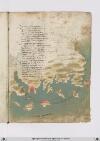
P. 26 Etcon lacharta dove sono sengniati iventi eporti etutta lamarina vanno per mare merchatanti e pirrati que per ghuadagno lialtri per rapina einunpunto ricchi osventurati sono allevolte dasera amattina alla fortuna inalchunaltra chosa nonsidimostra tanto rovinosa
Colbossolo dellastella temperata dichalamita verso tramontana veghono apunto ove laprola ghuata ese dalsuo viaggio sallontana eccoltimone dirizza ongni ifiata lanave quando sta conmente sana suso ilnochieri inboccha achomandare dipunto inpunto chevia debba fare
Tirano lantenna piu bassa opiu alta secondo iltempo temperato o forte equando daunvento adalto salta bisongna chevisieno legienti accorte avolgiere ecomettendo difalcha subito sono aperichol dimorte e sopra tutte cose alnavichare bisongna essere sollecito eveghiare
16r
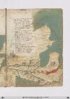
P. 31 VIen dascciloccho unbraccio dalto mare che percolore difondo edetto rosso checiento miglia largho quasi appare lungho e disteso amisura dunfosso etorto comuno archo eviene a fare suotermine econfine sopraldosso delchayro dibanbillonia tre giornate dovebbe faraone lesue derrate
Datramontana diquestasia grande tartari sono sotto la freddazona giente bestiale di leggi eddivivande findove londa del bachu rinsuona perquesta terra ungram fiume sispande chedaltri due edile e tiro sadona elpiu deltempo elfreddo loncristalla edevisu lagram citta disalla
Eldetto fiume mette inungram seno dacqua salata chiuso daongni banda ditanto giro pocho piu homeno quanto cha ilmar maggiore lasuo gherlanda daluno alaltro mare aditerreno otto giornate equasi adranda adranda sta dallevante dritto eddiquagiu lagran ciptta sinoma dalbachu
[Image: Right and lower margins, a map of Asia Minor and the Levant as far as Egypt, continued from fol. 15v. Labels left to right and top to bottom: in left gutter (label: [a]rca [di]noe), and the city of (label: Nineve), with the Tigris, here (label: fiume nillo) with cities (label: baldac) and (label: Caldea) along it, flowing into the (label: arabico sinus). Below the Nile/Tigris, the river (label: Eufrates) and the city of (label: babillonia) along the Arabian Gulf, with Mecca (label: lameche) on the peninsula between the Gulf and the Red Sea (label: .M. rosso), with (label: Arabia) beyond. At bottom, the coast of the Mediterranean, with (label: damasco), (label: Monte libano), (label: Giudea), (label: gierusalem), the real Nile (label: fiume nillo), and a second city labeled (label: babillonia), actually Cairo/Fustat. Bodies of water have been painted in grey-green, with the exception of the Red Sea which has been painted in red. Each city on this map has been labeled in black and is accompanied by a depiction of a fortification. Two of the fortifications, specifically Caldea and the first babillonia, are flying the flag of St. George. There is a scribal note (note: Az) directing the artist to paint the bodies of water in azzurro (blue) at the top of the peninsula above the Red Sea. However, the pigment used appears to be more a grey-green than blue.]
19v
P. 38 Niffe zamor saffi ghazola emessa una dopo laltra cinquanta inottanta miglia si truova poy dila daessa epiu oltre nonpare chenascha pianta nechessitruovi senon rena spessa cierchando lariviera tutta quanta veggiono daterra piu isole imare canaria ealtre dipoccolo affare
Seghuendo illito verso loriente treciento miglia sta hone insalmare disopra asetta andando colponente echi atremisen volessi andare fraterra atre giornate oquasimente one chonchartagine sta delpare afar pileggio chonvento africhone dugiento otanta miglia adacquilone
Poy trallevante egrecho sta horano piu alto cientomiglia insuquellito lacipta ditenes per quella mano piu su cientocinquanta tiensuo sito epoccho piu diciento dilontano quella dalgieri laquale diriza ildito adacquamorta verso tramontana questo paese apocha terra piana
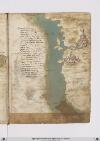
[Image: Left and lower margins, a map of the coast of Spain and north Africa from Gibraltar to Cartagena and Algiers. The large body of water (label: Mare mediterano) is painted in grey-green with a wave pattern in a light brown. In the (label: Mare di Spagnia) there is an unlabeled island, representing Majorca, which has been painted with a few strokes of red. A scribal (note: Ro[sso]) calling for red is visible at the top of the island.
Many cities and regions are labelled. On the left/European side, top to bottom: (label: Cartagena), (label: Almeria), (label: Saruignia), (label: Granata), (label: Lisbona), (label: Spagnia), (label: Indi), (label: Sibilia). On the right/African side: (label: Algieri), (label: Brescia), (label: Mestegani), (label: Arçeu), (label: Orano), (label: Seren), (label: One), (label: Melina). All are in red ink except for "Indi" (?) in black.]
21r
P. 41 Guata allessandria perponente setta eghuata atramontana satalia eterra riccha nobila eperfetta edigram porto dimerchatantia daindi alfiume dovelnilo imar gitta cinquanta miglia sono perdiritta via echiamasivi ilfiume dirositto esono tremila miglia dallostretto
Unaltra focie sanza fargirata piu su cinquanta miglia ilmar dichina passata quella truovi damiata poi sono dugiento miglia dimarina fino allarassa che elapiu ingholfata echa piu almar rosso savicina equivi dallevante atramontana Illito dira etutta terra piana
Dallarissa allayazza derminia ritta costiera sonmiglia seciento pertramontana tutta quellavia vaverso grecho perquarta divento Ilporto dibaruti desoria nelmezzo sta apunto alletreciento equindi sono achilpileggio piglia fino allisandria cinqueciento miglia
[Image: Right margin, a map showing the continuation of the north African coast, from top to bottom / east to west: (label:Larissa), (label:Egipto disopra), (label:damiata), (label:babbillonia), the Nile ((label:fiume nilio), (label:Egipto disotto), (label:Allexandria), (label:Golfo della rissa), (label:lucho). Small, detailed illustrations of Alexandria and "Babbillonia", e.g. Cairo, are given: "Babbillonia" shows a castle on a hill above a walled town, while Alexandria is more of a small walled city with a flag of St George flying above it.]
23r
P. 45 Rodi euna isoletta cheschostata daterra ferma qualche miglia venti edacientocinquanta esuogirata equivi volgie illito adaltri venti insino atenedon diritto ghuatta quella chostiera miglia quatroccientoventi amaestralle ver tramontana aquarta secondo chessivede insulla charta
Vero e chedigrani gholfi aquesto lito chentram fraterra edigrani capi imare ede daassai ebuoni porti fornito dovelnavilio sechuro possa faare [corr. fire?] fraterra abuone ville eforte sito etemperto esano perabitare esta diritto chonitalia efrancia equesta giente porta bensuo lancia
Quivi alto luogho presso alameta deldetto fregho adeffesa vicina lesmirre foya lardemiti inqua tutti sonpoi ingholfi dimarina poi quasi alfine fu lagram citta ditroya dove fu lagram rovina del superbo ylion chefu conbusto onde fu laprogenia daghusto
[Image: Bottom and right margins, a map of the eastern coast of Anatolia with bluish-green water (label: PARTE DARCHIPELAGO) and brown/gray brush strokes for the land. Islands are labelled in red, (label: Tenedon), (label: Metellino), (label: famo), (label: lango), and (label: Rodi), and cities on the mainland in red: (label: Troya), (label: landermit), (label: Messa), (label: Alto luogo). The islands of Metellino and Rhodes are decorated with red brushstrokes, but Rhodes has a white penwork Maltese cross instead of a text label. The city of Troy is marked with dramatic flames surrounding a large harbor.]