Pages That Mention Rosseto
BnF. Bibliothèque de l'Arsenal. Ms-8536
75r
p. 40/ f. 75r
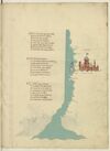
¶ Quata Alexandria per ponente setta E guata a tramontana Satalia E terra richa nobil e perfecta E de gran porto di mercadantia Da indi e focie ove il nillo in mar getta Cinquanta miglia sum per drita via E chiamasi Ivi il fiume del rosseto Che sum trea millia miglia dal strecto
¶ Un’altra foce sença fare girata Piu su cinquanta miglia al mar dichina Passato quello trovi damiata Poi sum ducento miglia di marina Fin a larissa che -e- la piu ingolfata Che piu al mar rosso s’avicina E quivi da levante a tramontana Il lito gira e tuta terra piana
¶ Da larissa a laiaça d’ermenia Rita costiera sum miglia seicento Per tramontana tuta quella via In verso greco per quarta di vento Il porto di baruti di soria Nel meço sta a puocco a le trecento E quindi sono a ch'il pilglia Fino Alexandria cinquecento miglia
[image, right margin and lower margin: Map depicting a stretch of the Egyptian coast. Ocean painted aquamarine with wave pattern in grey. At ¶ 2: on a tributary extending rightwards sits a fortified city; above it, in red ink: (label: CHAIRO .); below it, in red ink: (label: chairo de babilonia). The city, tinted reddish-brown with blue roofs, includes a tower with a blue-and-white-striped dome from which flies a flag, yellow with crenelated edge, bearing: Escutcheon Azure overall a Moor’s head proper, couped, blindfolded Argent. At the mouth of the tributary, two islands: one outlined with a reddish-pink wash; the other painted blue with a white diamond marked /d/ in red ink, the remainder of its name—(label: damiata)—continuing on the nearby coast. Location names along the coastline, top to bottom, in red ink: (label: Larissa), (label: Rosseto), (label: alexandria), (label: Lucho).]