Pages That Mention angholo
BnF. Bibliothèque de l'Arsenal. Ms-8536
74v
p. 39/ f. 74v
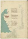
¶ D'africa a chapolia ad a facesse Sum molte seche da lato remote E chi vol navicar indi a chapesse Fra epsi -e- litto per canal si puote E seguen poi fin a rassa mabesse Ma qui bisogna che de fuora sia ruote Da tunis insin qui per maestrale Trecento miglia sum per dritto strale.
¶ Poi tripoli cita de barbaria Cinquanta cinque miglia inver levante E misurata su per quella via Ducento miglia e duo volte atretante Sum fin a rusen per traversia Dove fa capo il gran monte athalante Lassando uno golfo ov'e a man drita Çianarra e poi Sernich e tholomita
¶ E chi girasse il golfo per costiera Serebon piu de le miglia ducento Dal cavo di rausem a bonandria Sum cento miglia pur per dricto vento Lucho piu su ducento par che stia E indi ad Alexandria a quatro cento E quasi in meço d'epse sta la rassa E questo paese -e- terra bassa
[image, left margin: Map with east at the top depicting a stretch of the Algerian and Tunisian coasts up to the Gulf of Gabes with Kerkennah Islands and Djerba. Ocean painted aquamarine with wave pattern in grey; the coastline heightened yellow. At top, three islands are in a darker green. Near ¶ 2 there is a a reddish-brown city with blue domes and spires. Placenames: in the water, close to the first two islands, in red ink, vertically, (label: cherchani). On the mainland, in red ink, from the top down: (label: Ixola de gierbi), (label: Caps), (label: fachse), (label: susa); in black ink, (label: cavo bono). The city is named as (label: Tunis.); further names, continuing down the coast, in red ink: (label: Cartagine), (label: biserto), (label: Bona), (label: angholo), (label: Bugiea), (label: algieri).]