Pages That Mention Laiaça
Vat.lat.7612 Place names identified
22r
P. 43 Dabaruti infraterra una giornata euna mezza equella gram ciptade chentutto ilmondo etanto nominata merchatantischa edinobile a fare possente ericha domascho chiamata cheniuna dimaggiore antichitade sopra laterra nontrovian chessia edestata gramfatto tuttavia
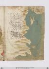
Tripoli disoria seghue permare sessanta miglia epoi trenta tortosa lalecca poi settanta inquello andare etutta questa eterra montuosa finpoi cinquanta miglia dove appare la foccie disoldino assai famosa poy e allisandretta altre cinquanta einfino allaiazza poi quaranta
Anghulo achuro fa qui lamarina evolgie molti venti eaponente verso libecco aquarta sidichina fino adantiocietta equasimente laiazza aciento miglia savicina altarso epoi quaranta leseghuente alciurcho epoi palopoli esettanta edanntiocietta apoi novanta
[Image: Right and bottom margins, a map of the northeastern Mediterranean coast from Laiazzo to Messi, including the islands of Cyprus (label: Cipri) and Rhodes (label: Rodi). Mainland cities in order from top to bottom / east to west: (label: Laiaça), (label: Cirso), (label: Palopoli), (label: Onocina), (label: Candelor), (label: Setalia), (label: Messi).]
BnF. Bibliothèque de l'Arsenal. Ms-8536
75r
p. 40/ f. 75r
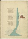
¶ Quata Alexandria per ponente setta E guata a tramontana Satalia E terra richa nobil e perfecta E de gran porto di mercadantia Da indi e focie ove il nillo in mar getta Cinquanta miglia sum per drita via E chiamasi Ivi il fiume del rosseto Che sum trea millia miglia dal strecto
¶ Un’altra foce sença fare girata Piu su cinquanta miglia al mar dichina Passato quello trovi damiata Poi sum ducento miglia di marina Fin a larissa che -e- la piu ingolfata Che piu al mar rosso s’avicina E quivi da levante a tramontana Il lito gira e tuta terra piana
¶ Da larissa a laiaça d’ermenia Rita costiera sum miglia seicento Per tramontana tuta quella via In verso greco per quarta di vento Il porto di baruti di soria Nel meço sta a puocco a le trecento E quindi sono a ch'il pilglia Fino Alexandria cinquecento miglia
[image, right margin and lower margin: Map depicting a stretch of the Egyptian coast. Ocean painted aquamarine with wave pattern in grey. At ¶ 2: on a tributary extending rightwards sits a fortified city; above it, in red ink: (label: CHAIRO .); below it, in red ink: (label: chairo de babilonia). The city, tinted reddish-brown with blue roofs, includes a tower with a blue-and-white-striped dome from which flies a flag, yellow with crenelated edge, bearing: Escutcheon Azure overall a Moor’s head proper, couped, blindfolded Argent. At the mouth of the tributary, two islands: one outlined with a reddish-pink wash; the other painted blue with a white diamond marked /d/ in red ink, the remainder of its name—(label: damiata)—continuing on the nearby coast. Location names along the coastline, top to bottom, in red ink: (label: Larissa), (label: Rosseto), (label: alexandria), (label: Lucho).]