Pages That Mention algieri
Vat.lat.7612 Place names identified
19v
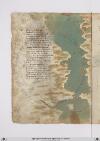
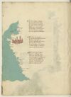
P. 38 Niffe zamor saffi ghazola emessa una dopo laltra cinquanta inottanta miglia si truova poy dila daessa epiu oltre nonpare chenascha pianta nechessitruovi senon rena spessa cierchando lariviera tutta quanta veggiono daterra piu isole imare canaria ealtre dipoccolo affare
Seghuendo illito verso loriente treciento miglia sta hone insalmare disopra asetta andando colponente echi atremisen volessi andare fraterra atre giornate oquasimente one chonchartagine sta delpare afar pileggio chonvento africhone dugiento otanta miglia adacquilone
Poy trallevante egrecho sta horano piu alto cientomiglia insuquellito lacipta ditenes per quella mano piu su cientocinquanta tiensuo sito epoccho piu diciento dilontano quella dalgieri laquale diriza ildito adacquamorta verso tramontana questo paese apocha terra piana
[Image: Left and lower margins, a map of the coast of Spain and north Africa from Gibraltar to Cartagena and Algiers. The large body of water (label: Mare mediterano) is painted in grey-green with a wave pattern in a light brown. In the (label: Mare di Spagnia) there is an unlabeled island, representing Majorca, which has been painted with a few strokes of red. A scribal (note: Ro[sso]) calling for red is visible at the top of the island.
Many cities and regions are labelled. On the left/European side, top to bottom: (label: Cartagena), (label: Almeria), (label: Saruignia), (label: Granata), (label: Lisbona), (label: Spagnia), (label: Indi), (label: Sibilia). On the right/African side: (label: Algieri), (label: Brescia), (label: Mestegani), (label: Arçeu), (label: Orano), (label: Seren), (label: One), (label: Melina). All are in red ink except for "Indi" (?) in black.]
20r
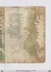
P. 39 Indi adbuggiea sonmiglia ciento venti pur trallevanta egrecho eposccia ebona piu su dugiento pur perdetti venti eluna elaltra cipta siragiona dayvi aciento miglia poi seghuenti truovi biserti esecondo chesuona performa quivi presso fu chartagine lagrande esene vede alchuna ymagine
Tunisi fapiu la suo residenza sesantta miglia edun gran gholfo aporto laqual citta sighuarda chon fiorenza aduno occhaso quasi edunorto capo direngno ede digram potenza eben dotata terra enon atorto chelle nelmezzo dillabarberia presso aitalia piu chaltra visia
Sta con Jerusalem econsibilia inclinati dacuro edazaffiro esta vicina perdugiento miglia alleduo maggiorisole digiro lequali sono lasardingna ellascicilia quasi intriangholo quando ben vimiro africha stapo[i] vermeridiano passato capo bono adestra manno
[Image: Right margin, a map of the Mediterranean Sea including (on left) the southern tip of Sardinia (label: SARDIGNIA), then from top to bottom (east to west) at right, the western tip of Sicily (label: Sicilia), and the North African coast: (label: Sussa), (label: Cartagi), (label: bona), (label: Tuniçi), (label: biserti), (label: Bona) again, (label: Storia), (label: bugea) with a small image of a walled city, (label: titelis) (modern Dellys, Algeria), and (label: Algieri). The Mediterranean is colored in a grey-green wash.]
BnF. Bibliothèque de l'Arsenal. Ms-8536
73v
p. 37/ f. 73v
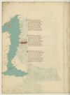
¶ Niffe çiamor gaçiola e messa Una doppo l'altra cinquanta e octanta Miglia si trova poi di la da essa E piu oltra non par che nasca pianta Ne che se trovi se non rena spessa Cercando la riviera tuta quanta Vegion da terra piu insule in mare Channariam e- altri di picolo afare
¶ Seguendo il lito verso l'oriente Trecento miglia sta hone sul mare Di sopra setta andando col ponente E chi a tremissen volesse andare Fra terra e tre giornate e quasimente Hone cum carthagine sta del pare Affar pilegio con vento affricone Ducento trenta miglia ad aquilone
¶ Poi tra levante e greco sta orano Piu alto cento miglia in su quel litto La cita de tenes per quella mano Piu su cento cinquanta tien suo sito E puoco piu di cento di lontano Quella d'algeri la qual diricia il dicto Ad acqua morta verso tramontana Questo paese ha poca terra piana
[image, left margin: Map with east at the top depicting the northwestern coast of Africa, the Strait of Gibraltar, the southern coast of Spain, and the island of Majorca. The sea is painted aquamarine with wave pattern in grey; the coastline in grey with a yellow shadow. At top, an island in yellow and red stripes (the Pales of Aragon), a reddish-brown city with blue domes is near ¶2 on the right side of the sea. To the right of the sea, from the top downwards, in red ink: (label: Algieri), (label: Tenese), (label: Orano), (label: onne), (label: Tremisem), (label: Setta). In the water, written vertically, in red ink (label: Streto in Gibilterra). In left margin, from the bottom upwards, in red ink, text rotated 180°: (label: Cades), (label: Malades), (label: Sciavignia), (label: Ameria), (label: Cartagine), (label: Valencia). At the top of the sea, on the mainland, the island is identified in red ink as (label: Maiolica).]
74r
p. 38/ f. 74r
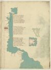
¶ Indi algieri son miglia cento vinti Tra levante e grecco e posta bona Piu su ducento pur per dicti venti E l'una e l'altra cita si ragiona Da Ivi a cento trenta poi seguenti Trovi misserti che secondo che se rasona Per fama quivi presso fu carthagine La grande e si se vede alcuna ymagine
¶ Tunis fa piu la su residentia Sexanta miglia e d'un gran golfo ha porto La qual cita si guata cum firencia Ad un occasso on quasi ad un horto Capo di regno e di gran potentia E ben doctata terra e none a torto Ch'ella -e- nel meço de la barbaria E presso a Italia piu ch'altra vi sia
¶ Sta cum ierusalem e cum sibilla Inclinati da choro e da çephiro E sta vicina per ducento miglia A le due magior insule de giro Le qual sum la sardegna e la cicilia Quasi in triangulo quando ben vi miro Africa sta poi ver merediano Passato cavo bono a dextra mano
[image, from top down left margin and across bas de page: Map depicting a stretch of the Tunisian coasts and Libyan coasts from Cape Bon (Tunis) to the Gulf of Sidra with the Kerkennah Islands and Djerba. Ocean painted aquamarine with wave pattern in grey. On gutter-side shore, at ¶ 2: a fortified city in reddish-brown with blue roofs. Atop water at ¶ 1: three islands in green; on the water nearby, in red ink (label: cherchani). In top margin, inverted, in black ink: (label: Cavo bono). In left margin, from top downwards, in red ink: (label: Susa), (label: africa), (label: fachse), (label: Caps), (label: ixola di gervi), (label: rasamabes), (label: tripoli di barbaria .), and (inverted) (label: misurata). Bas de page, from left clockwise, in red ink: (label: Çianara), (label: Brinch), (label: Tolometa); in black ink: (label: Cavo de rausem); in red ink: (label: bonandrea), (label: luco).]
[image, right margin at ¶ 2: Map of an island, tinted green with rivers indicated by waving blue lines. Written vertically, in red ink (left to right): (label: mesina), (label: Ixola de cicilia).]
[image, right margin at ¶ 3: Map of an island, tinted pink, within a small patch of water painted aquamarine with wave pattern in grey. Upon the island, in black ink: (label: Ixola di sardigna); also on the island, above this, in red ink, inverted: (label: Calici).]
74v
p. 39/ f. 74v
¶ D'africa a chapolia ad a facesse Sum molte seche da lato remote E chi vol navicar indi a chapesse Fra epsi -e- litto per canal si puote E seguen poi fin a rassa mabesse Ma qui bisogna che de fuora sia ruote Da tunis insin qui per maestrale Trecento miglia sum per dritto strale.
¶ Poi tripoli cita de barbaria Cinquanta cinque miglia inver levante E misurata su per quella via Ducento miglia e duo volte atretante Sum fin a rusen per traversia Dove fa capo il gran monte athalante Lassando uno golfo ov'e a man drita Çianarra e poi Sernich e tholomita
¶ E chi girasse il golfo per costiera Serebon piu de le miglia ducento Dal cavo di rausem a bonandria Sum cento miglia pur per dricto vento Lucho piu su ducento par che stia E indi ad Alexandria a quatro cento E quasi in meço d'epse sta la rassa E questo paese -e- terra bassa
[image, left margin: Map with east at the top depicting a stretch of the Algerian and Tunisian coasts up to the Gulf of Gabes with Kerkennah Islands and Djerba. Ocean painted aquamarine with wave pattern in grey; the coastline heightened yellow. At top, three islands are in a darker green. Near ¶ 2 there is a a reddish-brown city with blue domes and spires. Placenames: in the water, close to the first two islands, in red ink, vertically, (label: cherchani). On the mainland, in red ink, from the top down: (label: Ixola de gierbi), (label: Caps), (label: fachse), (label: susa); in black ink, (label: cavo bono). The city is named as (label: Tunis.); further names, continuing down the coast, in red ink: (label: Cartagine), (label: biserto), (label: Bona), (label: angholo), (label: Bugiea), (label: algieri).]