Pages That Mention Niffe
Vat.lat.7612 Place names identified
19v
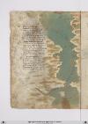
P. 38 Niffe zamor saffi ghazola emessa una dopo laltra cinquanta inottanta miglia si truova poy dila daessa epiu oltre nonpare chenascha pianta nechessitruovi senon rena spessa cierchando lariviera tutta quanta veggiono daterra piu isole imare canaria ealtre dipoccolo affare
Seghuendo illito verso loriente treciento miglia sta hone insalmare disopra asetta andando colponente echi atremisen volessi andare fraterra atre giornate oquasimente one chonchartagine sta delpare afar pileggio chonvento africhone dugiento otanta miglia adacquilone
Poy trallevante egrecho sta horano piu alto cientomiglia insuquellito lacipta ditenes per quella mano piu su cientocinquanta tiensuo sito epoccho piu diciento dilontano quella dalgieri laquale diriza ildito adacquamorta verso tramontana questo paese apocha terra piana
[Image: Left and lower margins, a map of the coast of Spain and north Africa from Gibraltar to Cartagena and Algiers. The large body of water (label: Mare mediterano) is painted in grey-green with a wave pattern in a light brown. In the (label: Mare di Spagnia) there is an unlabeled island, representing Majorca, which has been painted with a few strokes of red. A scribal (note: Ro[sso]) calling for red is visible at the top of the island.
Many cities and regions are labelled. On the left/European side, top to bottom: (label: Cartagena), (label: Almeria), (label: Saruignia), (label: Granata), (label: Lisbona), (label: Spagnia), (label: Indi), (label: Sibilia). On the right/African side: (label: Algieri), (label: Brescia), (label: Mestegani), (label: Arçeu), (label: Orano), (label: Seren), (label: One), (label: Melina). All are in red ink except for "Indi" (?) in black.]
Yale: Beinecke MS 946 Place Names Identified

Page 40
P. 40 Niffe çamor saffi gaçola et messa una po l'autra cinquanta inn otanta miglian si truovan poi da essa e piu oltre non par che nasca pianta ne che si truovi se non rena spessa cercando la rivera tutta quanta veggion da terra piu il sol in mare canaria et altri di piccolo affare.
Seguendo il lito verso l'oriente trecento miglia sta one in sul mare di sopra setta andando col ponente et chi a tremison volesi andare fra terra e tre giornate o quasimente one con cartaginea sta del pare a far pilegio et con vento africone dugento trenta miglia ad aquilone.
Piu tra levante et greco sta orano piu alto cento miglia in su quel lito la cipta di tenes per quella mano piu su cento cinquanta tien suo sito et poco piu di cento di lontano quella d'algeri la qual driça il dito ad acqua morta verso tramontana questo paese a poca terra piana.
BnF. Bibliothèque de l'Arsenal. Ms-8536
73r
p. 36/ f. 73r
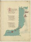
INcominciando dal meridionale Litto del mare in su la strecta bocha Che miglia sedece e largo il canale E d'ogni parte monti e rocha Sta la cita de seta la qual sale Sei giorni a greco di sopra a manrocha Ed altretanto e dirimpecto ad epsa Per meço de la gran cita di fessa
¶ Di soto a seta forsi a mille miglia Giu par quel litto s'a pocha notitia D'andarvi l'uno l'altro se consiglia Ne per dilecto ne per avaritia E gia ne furno che per maraviglia Volgion passar piu ultra e con tristitia Di lor e di lor gente far tal gita Che mai poi non si seppe di lor vita
¶ In queste mille miglia di marina Verso libecio trovi prima arcilla E poi larachale asai vicina Sala poi siegue che una bona villa Un fiume che al lato li confina Che dal monte athalante si distilla Per meço fessa passa e cencinquanta Miglia in sin la -e- da setta altretanta
[initial: Opening initial /I/, 4 lines, in blue with red pen flourishing heightened in yellow.]
[image, right margin and bas de page: Coastal map of north-western Africa and part of south-west Spain. Ocean painted aquamarine with wave pattern in grey. At top, two small islands, both painted red. In right margin, across from ¶ 1–¶ 2: a fortified city in reddish-brown with blue roofs; below this, a tower in reddish-brown with a blue-and-white striped dome. Bas de page, curving up towards the right margin, a chain of larger islands—the seven islands of the Canaries—painted (left to right): yellow, pinkish-red, blue, red, grey, grey-green, and white with a red cross (i.e. cross of St George), the last of these surrounded by five tiny islets in red. City names, in red ink, from top of page downwards: (label: Sibilia), (label: Cades), (label: Setta), (label: Arcilla), (label: laracha), (label: sala), (label: fessa), (label: niffe), (label: giamor), (label: marocha), (label: saffi), (label: gaziolla), (label: messa). Bas de page, also in red ink, on the waters adjacent to the Canaries: (label: camariam).]
73v
p. 37/ f. 73v
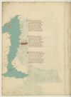
¶ Niffe çiamor gaçiola e messa Una doppo l'altra cinquanta e octanta Miglia si trova poi di la da essa E piu oltra non par che nasca pianta Ne che se trovi se non rena spessa Cercando la riviera tuta quanta Vegion da terra piu insule in mare Channariam e- altri di picolo afare
¶ Seguendo il lito verso l'oriente Trecento miglia sta hone sul mare Di sopra setta andando col ponente E chi a tremissen volesse andare Fra terra e tre giornate e quasimente Hone cum carthagine sta del pare Affar pilegio con vento affricone Ducento trenta miglia ad aquilone
¶ Poi tra levante e greco sta orano Piu alto cento miglia in su quel litto La cita de tenes per quella mano Piu su cento cinquanta tien suo sito E puoco piu di cento di lontano Quella d'algeri la qual diricia il dicto Ad acqua morta verso tramontana Questo paese ha poca terra piana
[image, left margin: Map with east at the top depicting the northwestern coast of Africa, the Strait of Gibraltar, the southern coast of Spain, and the island of Majorca. The sea is painted aquamarine with wave pattern in grey; the coastline in grey with a yellow shadow. At top, an island in yellow and red stripes (the Pales of Aragon), a reddish-brown city with blue domes is near ¶2 on the right side of the sea. To the right of the sea, from the top downwards, in red ink: (label: Algieri), (label: Tenese), (label: Orano), (label: onne), (label: Tremisem), (label: Setta). In the water, written vertically, in red ink (label: Streto in Gibilterra). In left margin, from the bottom upwards, in red ink, text rotated 180°: (label: Cades), (label: Malades), (label: Sciavignia), (label: Ameria), (label: Cartagine), (label: Valencia). At the top of the sea, on the mainland, the island is identified in red ink as (label: Maiolica).]