Pages That Mention rodi
Kenneth Spencer Research Library, Pryce MS P4 Place Names Identified

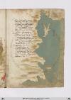
Page 45
P. 45 Tral tarso et antiochecta dricta via Cipri isola infra mare sta discosta Un ciento miglia dove nicosia Cicta reale fra terra e/ famagosta Che fu gran porto di mercatantia Sul mare doriente e quella costa Dillysola girando e/ cinque cento E per lungheçça son miglia duciento Tralla lecha e/ tortosa ad oriente Lisosa decta guata la marina Et per dricta çona in ver ponente Guarda rodi e modon e poi messina Echalliu e maiorcha epoiseguente Vallença aportogallo et e/ vicina Famagosta abaruti per due .cc. Ensino allexandria per un .c. Dantrochecta arodi per quel vento Decto di sopra sanza costeggiare Ricto pileggio son miglia trecento Ma converracti due golfi lasciare Che sarrebbe piu longha da duciento Miglia la costa avolerla girare Nel primo e/ candeloro e desetelia Elaltro pare che quelli di matrisia
[Image: Right margin, oriented with East at the top, a portolan-style map of the northeastern part of the Mediterranean coast, which is freely outlined in ink and shaded with a green wash. The island of Cyprus (label: cipri.) appears near the top, washed light brown, with the cities of Famagusta (label: famagosta) and Nicosia (label: nicosia). Below that, the island of Rhodes (label: rodi) appears in red. Between the two islands, the Mediterranean Sea is named (label: pontus.). A distance line between the two islands is labeled in unidentified units (label: 300). To the right, two other numbers (labels: 200 and [700?]) are not associated with visible distance lines. Various ports are labeled along the coasts of modern Lebanon, Syria, and Turkey; starting from the southernmost port (the top right of the page) and moving north and west (counterclockwise), they are: Beirut (label: baruti), Tartus (label: tortosa), [Latakia/Laodiceia?] (label: la lecha), [Alajah?] (label: la laha), Tarsus (label: tarso), Corycus (label: curchio.), Polopoli (label: palopoli.), [?] (label: artiozetta.), Alanya (label: candelor), Antalya (label: satelia.), Fethiye (label: macri), and [Kastellorizo/Meyisti?] (label: messi).]

Page 46
P. 46 ROde e/ una ysola che e/ scostata Da terra ferma qualche miglia vencti E da ciento cinquanta e sua girata Equivi voglie illito ad altri venti Ensino atenedon dricto guata Quella costiera miglia quatro centi Ad maestral ver tramontana ad quarta Secondo che si vede insula carta Vero e/ che di grangolfi aquesto lito Chentranfra terra e/ di gran capi in mare Et e/ dassai et bon porti fornito Dovel navili sicuro possa store Fra terre et bon ville e forte sito Etemperato e/ sano per habitare Esta dricta con ytalia et francia Et quella gente porta ben sua lancia Quivi e/ alto luogho pressa altameta Del decto frego ad epheso vicina Le smirne fuya elanderimicti inqua Tuctesonpoi in golfi dimarina Poi quasi alfine fu la grancipta Di troya dove fo la gran royna Del soperbo ylion che fo conbustio Onde fula progenie dagusto
[Image: Lower margin, a portolan-style map illustration showing the Mediterranean coast of Turkey. Islands or ports, left to right, are: Lemnos (label: iambro), Tenedos (label: tenedo), Mitilini (label: metelmo) on Lesbos, Chios (label: assio.), Samos (label: xamo.), Kos (label: Lango), and Rhodes (label: rodi.). To the right of the Dardanelles (label: [elis?]ponto), the cities/ports tentatively identified on the Turkish mainland, left to right, are: [?] (label: ruto?), Troy (label: troia), Edremit (label: landermitti.), [Foça?] (label: foia.), İzmir (label: lasmirne.), Selçuk (label: alto loro), and Milas (label: messi).

Page 47
P. 47 Quactro ysolecte da ciento in septanta Miglia di giro ogniun e/ presso allito Amendi venti e/ son di lunghi octanta Luna alaltra per dricto rito Son da poi rodi e la prima si canta Langho e/ poi laltra che tene il suo sito Di contra ad alto luogho e decta ssamo Schio laltra e laltra metellin la chiamo Ora entra nel strecto di torchia Che e/ circa septe miglia in boccha Verso greco esol perquesta via Il decto mare nel mar magiore rimboccha E ciento octanta miglia par che sia Per decto vento insinla ove toccha Le mura dilla imperial cicta Che sulaltra boccha piu strecta sta La cicta davrosta nel cominciare Dalla man dextra dentral decto strecto Onde verso aquilone aguardare Galipoli cicta ve dirmipecto Et poi piu su comincia ad rallargare E ben sexanta miglia ha di tragiecto Da diaschilo che pur da man ei dextra Fin alla boccha strecta da sinestra
[Image: Right margin, a portolan-style map illustration showing Sea of Marmara labeled at center (label: marmora) beneath line indicating distance in unspecified units (label: [60?]). Place names on the north shore (left, bottom to top) are: Gallipoli (label: garipoli), Constantinople (label: costantinopoli), Pera (label: pera). Place names on the south shore (right, top to bottom) are: Üsküdar (label: scutario), İzmit (label: comedio), Sakarya (label: palolimen), Eşkel (label: diaschilo). Tenedos (label: tenedo), an island in the Aegean Sea near the entrance to the Dardanelles, is colored red.]

Page 48
P. 48 QUesta boccha ha di largo due miglia Evencti ad aquilon dura il canale Egiungni al mare magiore dove sepiglia Seguendo illito verso orientale Una costiera novecento miglia Chensino ad trebosonda son sue scale Carpi poi pontarchia e samastoe Castelli sinopi e/ simissoe E son dalluna allaltra miglia ciento Una per altra equal meno equal piu Cosi dallaltro mare anche seciento Sonno dalla iazza insino a rodi giui Edal unmare allaltro quatro ciento Equesto quadro antichamente fu Decto asia maiore e dentro ase Havea molte provincie et molti Re Nel capo quasi desso quadro sta Il monte tauro che molto nominato Il quale due corna ver ponente fa Che vengon lungho Luno elaltro lato Nel mezo desse e/ oggi grancinata Savastro ove il gran turcho sta honorato Al pari da simisso da tramontana Equasti al tarso da meridiana
[Image: Left margin, a portolan-style map illustration showing Black Sea (label: mar magior) (label: pontus). The ports/cities along the coast on the left side of the illustration are, top to bottom, Sevastopol (label: savastopoli) and Pitsunda (label: pesonda). The ports/cities along the coast on the left side of the illustration are, top to bottom: Trabzon (label: tripesonda), Giresun (label: cirisonda), Fatsa (label: vatiza), Samsun (label: zimiso), Sinop (label: sinopi), Cide (label: castelle), Amasra (label: samasto), Ereğli (label: pontarachia), Kerpe (label: carpi).
Vat.lat.7612 Place names identified
22r
P. 43 Dabaruti infraterra una giornata euna mezza equella gram ciptade chentutto ilmondo etanto nominata merchatantischa edinobile a fare possente ericha domascho chiamata cheniuna dimaggiore antichitade sopra laterra nontrovian chessia edestata gramfatto tuttavia
Tripoli disoria seghue permare sessanta miglia epoi trenta tortosa lalecca poi settanta inquello andare etutta questa eterra montuosa finpoi cinquanta miglia dove appare la foccie disoldino assai famosa poy e allisandretta altre cinquanta einfino allaiazza poi quaranta
Anghulo achuro fa qui lamarina evolgie molti venti eaponente verso libecco aquarta sidichina fino adantiocietta equasimente laiazza aciento miglia savicina altarso epoi quaranta leseghuente alciurcho epoi palopoli esettanta edanntiocietta apoi novanta
[Image: Right and bottom margins, a map of the northeastern Mediterranean coast from Laiazzo to Messi, including the islands of Cyprus (label: Cipri) and Rhodes (label: Rodi). Mainland cities in order from top to bottom / east to west: (label: Laiaça), (label: Cirso), (label: Palopoli), (label: Onocina), (label: Candelor), (label: Setalia), (label: Messi).]