Pages That Mention ponente
Kenneth Spencer Research Library, Pryce MS P4 Place Names Identified

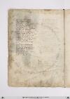
Page 44
P. 44 Da baruti infra terra una giornata E una mezza equel gran cictade Chentucto il mondo e tanto nominata Mercatantesta e/ di gran nobilitade Possente e/ riccha damasco chiamata Che neuna di magior antiquitade Sovra la terra non trovan che sia Et e/ stata gran facto tucta via Tripoli di soria]] segue per mare Sexanta miglia e poi trenta tortosa Laleccha poi septanta inquellandare Et tucta questa e/ terra montuosa fin poi cinquanta miglia dove appare La focie di soldino assai famosa poi elaxandria altre cinquanta E insino alla raçça poi quaranta Anguli cento fa qui la marina E voglie molti venti e ad ponente Verso libeccio a quaranta sidichina Fin ad antrochecta oquasi mente La iazza aciento miglia sa vicina Atarso e/ poi quaranta le seguente Il turcho e poi palopoli a septanta Et adantrochecta a poi novanta
[Image: Lower margin, a map of the Middle East, oriented with North at the top, extends from İskenderun to the Red Sea, drawn in brown ink. The River Jordan (label: fiume jordano) (colored green) flows from a range of hills (colored grey-brown) and connects the Sea of Galilea (label: mar de galilea) and the [Dead Sea?] (label: lago de sodoma). At the upper left Damascus (label: damasco.) appears as a group of 11 towers within a city wall. At the bottom center are Jerusalem (label: jerusalem), a cluster of 3 domes surrounded by 7 towers and a city wall and nearby Mout Zion (label: sion). The only other structure is the monastery of Saint Catherine (label: sancta k[a]tarina.) on Mount Sinai (label: monte sinai) at the far right. Other inland towns named are: Nazareth (label: nazaret) and Bethlehem (label: betelem). Regional place names are: Galilee (label: galilea), Samaria (label: samaria) and Judea (label: iudea). At the bottom of the page, the Mediterranean coast features the following ports, from north to south (left to right): İskenderun (label: alexandretta), [?] (label: soldino.), [Latakia/Laodiceia?] (label: la lecha.), Tartus (label: tortosa), Tripoli (label: Tripoli.), Beirut (label: baruti.), Sarepta/Zarephath (label: Saretta.), Acre (label: acri.), Caesarea (label: cesaria), Joppa (label: joppon.), Ashkelon (label: arsalona.), Gaza (label: gaza), and [El Arish?] (label: larissa).]

Page 45
P. 45 Tral tarso et antiochecta dricta via Cipri isola infra mare sta discosta Un ciento miglia dove nicosia Cicta reale fra terra e/ famagosta Che fu gran porto di mercatantia Sul mare doriente e quella costa Dillysola girando e/ cinque cento E per lungheçça son miglia duciento Tralla lecha e/ tortosa ad oriente Lisosa decta guata la marina Et per dricta çona in ver ponente Guarda rodi e modon e poi messina Echalliu e maiorcha epoiseguente Vallença aportogallo et e/ vicina Famagosta abaruti per due .cc. Ensino allexandria per un .c. Dantrochecta arodi per quel vento Decto di sopra sanza costeggiare Ricto pileggio son miglia trecento Ma converracti due golfi lasciare Che sarrebbe piu longha da duciento Miglia la costa avolerla girare Nel primo e/ candeloro e desetelia Elaltro pare che quelli di matrisia
[Image: Right margin, oriented with East at the top, a portolan-style map of the northeastern part of the Mediterranean coast, which is freely outlined in ink and shaded with a green wash. The island of Cyprus (label: cipri.) appears near the top, washed light brown, with the cities of Famagusta (label: famagosta) and Nicosia (label: nicosia). Below that, the island of Rhodes (label: rodi) appears in red. Between the two islands, the Mediterranean Sea is named (label: pontus.). A distance line between the two islands is labeled in unidentified units (label: 300). To the right, two other numbers (labels: 200 and [700?]) are not associated with visible distance lines. Various ports are labeled along the coasts of modern Lebanon, Syria, and Turkey; starting from the southernmost port (the top right of the page) and moving north and west (counterclockwise), they are: Beirut (label: baruti), Tartus (label: tortosa), [Latakia/Laodiceia?] (label: la lecha), [Alajah?] (label: la laha), Tarsus (label: tarso), Corycus (label: curchio.), Polopoli (label: palopoli.), [?] (label: artiozetta.), Alanya (label: candelor), Antalya (label: satelia.), Fethiye (label: macri), and [Kastellorizo/Meyisti?] (label: messi).]

Page 48
P. 48 QUesta boccha ha di largo due miglia Evencti ad aquilon dura il canale Egiungni al mare magiore dove sepiglia Seguendo illito verso orientale Una costiera novecento miglia Chensino ad trebosonda son sue scale Carpi poi pontarchia e samastoe Castelli sinopi e/ simissoe E son dalluna allaltra miglia ciento Una per altra equal meno equal piu Cosi dallaltro mare anche seciento Sonno dalla iazza insino a rodi giui Edal unmare allaltro quatro ciento Equesto quadro antichamente fu Decto asia maiore e dentro ase Havea molte provincie et molti Re Nel capo quasi desso quadro sta Il monte tauro che molto nominato Il quale due corna ver ponente fa Che vengon lungho Luno elaltro lato Nel mezo desse e/ oggi grancinata Savastro ove il gran turcho sta honorato Al pari da simisso da tramontana Equasti al tarso da meridiana
[Image: Left margin, a portolan-style map illustration showing Black Sea (label: mar magior) (label: pontus). The ports/cities along the coast on the left side of the illustration are, top to bottom, Sevastopol (label: savastopoli) and Pitsunda (label: pesonda). The ports/cities along the coast on the left side of the illustration are, top to bottom: Trabzon (label: tripesonda), Giresun (label: cirisonda), Fatsa (label: vatiza), Samsun (label: zimiso), Sinop (label: sinopi), Cide (label: castelle), Amasra (label: samasto), Ereğli (label: pontarachia), Kerpe (label: carpi).

Page 49
P. 49 Seguitan poi vatizza e/ ciriçonda Di ciento in ciento miglia in verlevante Seguendo illito e poi e tribisonda Equivi muove unarcho rivoltante Fin dirimpecto la ove pessonda Che allun capo dallaltro distante Dugiento cinquanta miglia e/ ad girare Epur ciento miglia sarrebbon affare []Lovaci]] e faxo due fiumi piusu Fra terra vengon perla carchasia Et piu ad levante ista il mare di bachu Ele cicta dorganti e samachia E a tornar per decto lito ingiu Savastropoli truovivi in quella via Et poi peçonda e/ poi treciento miglia Dovel canal della cana si piglia IL dicto lito torna inver ponente El canal decto verso tramontana Poi son duciento miglia rictamente Inverso greco e/ trovasi la thana Edoveci movemmo prima mente Questa e/ la piu dilunghe ela piu strana Dove si navichi e finiscie equi Lasia magiore e il fiume tanay
Lower margin, a portolan-style map illustration drawn with pen and ink and colored with watercolor washes showing the junction of the Don River (Label: tanai) with the Sea of Azov (label: mar della tana).
Vat.lat.7612 Place names identified
16v
P. 32 Dalaltra parte persia parchessia ellito diquelmare damezzo dy e daponente verso laturchia ellagram terra riccha deltauri dellaquale adomascho atanta via quanto a datribusonda infino adli chesono daventi giorni enelsuo clima savastro anchora afirenze sadima [corr. vadima?]
Poy sono montangne chepergram paese stendono lebraccia esono digrande altura famose inniscriture epoche intese chedisaper lagiente apocho chura ondeschono igram fiumi hove siprese antichamente perlagiente pura essere ilparadiso di delitia perchella eterra dimolta letizia
Ditutti glielementi sommamente edongni cosa molto ben dotata intorno dongni parte parimente damolte buone terre circhundata esopra ditutte sta eminente che tutto ilmondo dintorno sighuata dicio chessipotessi imaginare questo paese solia abbondare