Pages That Mention baruti
Yale: Beinecke MS 946 Place Names Identified

Page 45
P. 45 Da / baruti infra terra una giornata et una meça quella gran ciptade che 'n tutto il mondo e tanto nominata mercatantesca et di gram nobiltade possente et ricca domasco chiamata che niuna di maggiore antichitade sopra la terra non trovian che sia et e/ stata gran fatto tutta via.
Tripoli di soria segue per mare sexanta miglia et poi trenta tortosa la leccia poi settanta im quel andare e tutta questa e terra montuosa fin poi cinquanta miglia dove apare la foce di soldino assai famosa poi e/ alexandretta altre cinquanta et insino alla iaça poi quaranta.
Angulo acuto fa qui la marina et volge molti venti et a ponente verso libeccio a quarta si dichina fino ad antiocetta o quasimente la iaça a cento miglia s'avicina al tarso et poi quaranta l'e/ seguente il curco et poi lapoli a/ settanta et ad antiocepta a poi novanta.

Page 46
P. 46 Tra 'l / tarso et antiocepta dritta via cipri infra mare stae discosta un cento miglia dov'e nicosia cipta real tra terra et famagosta che fu gran porto di mercatantia sul mar d'oriente et quella costa dell'isola girando e cinquecento et per lungheça son miglia dugento.
Tra la leccia e tortosa ad oriente l'isola detta guata la marina et per diritta çona inver ponente guarda rodi modom et poi messina et calcri et maiorica et poi seguente valença et portogallo et e vicina famagosta a baruti per due .C. insino ad alexandria per un d.
D'antiocetta et rodi per quel vento detto di sopra sança costeggiare ritto pilegio son miglia trecento ma converrati duo golfi lasciare che sarebbe piu lunga da / dugento miglia la coste a vollela girare nel primo e/ candiloro e / setelia et l'autro pare che quel di macri sia.
BnF. Bibliothèque de l'Arsenal. Ms-8536
69v-70r
p. 30/ f. 69v-70r
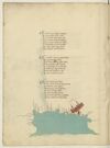
[Fol. 69v:]
[rubric: Frixon. Tigris. Eufrates.]
¶ Frison e l'altro molto ad oriente Che de li monti di persia al'india versia In verso lo sirocho 'a la corrente Tigris -e- il terzo che fa sua traversa Contra gli asirii che intra molto reprehende Eufrates -e- il quarto il qual sua mossa L'acque sue in chaverne e fa ritorno E l'uno e l'altra corre a meço çorno
¶ Quisti dui escon di monte ermini Dove posso dolpo 'l diluvio l'archa E tuti tri fano lungi camini In fin ch'al mar d'india ciaschum varcha Il qual mar par che stenda suo confini Venendo strecto di l'occeano marcha Fino in arabia a presso a sinai Giu per ponente abbassera echessi
¶ Quivi vengon de l'india e d'etiopia Le molte specierie a quelle gente Che vien per epse quando n'ano in copia E per conducere verso l'occidente Quivi ne vien una incredibil copia Per carovane e successivamente Mandano insieme di camelli gran mandaria Che portano a Damasco et Alexandria
[image, left margin: a stylized map showing two seas in aquamaine with a grey wave pattern. Both are annotated in red, the uppermost as (label: Mare de Bachu), the lower (label: MARE MAGIORE). They are separated by a stylised blue-tinted mountain range (label: Monte Tauro). The seas are joined by a small river, and another river begins in the mountain range and veers to left off of the page. The lower sea has several inlets and four labeled locations on the coast labelled in red, at 9 o'cock (label: Savastopoli), 11.30 (label: fascio), 12.30 (label: Lovati), and 2 o'clock a reddish-brown city with blue towers and domes (label: Trabisonda).]
[image, right margin at ¶2 : a red landmass with green grass (label: Monte erminio), surmounted with a golden structure (label: Archa de noe), upon which perches a dove with an olive branch.]
[image, right margin at ¶3: a yellow stylised landmass with tufts of green grass (label: Monte erminio) from which two rivers emanate, each annotated in red ink on f. 70r, the uppermost, (label: Fiume Tigris), and the lower (label: Fiume Eufrates) which flow over the gutter where the diagram is continued on f. 70r.]
[Fol. 70r:]
¶ Ven da sirocho un bracio d'alto mare Che per il color del fondo e dicto rosso Che cento miglia on piu ha afare Lungo e disteso a figura d'un fosso E torto como un archo e vien a fare Suo termino e confin sopra del dosso Del chiaro de babilonia tre giornate Dove hebe pharaon le sue derate
¶ Da tramontana de quest'axia grande Tartari sum sotto la freda zona Gente bestiale di lege e de vivande Fin dove l'onda di bachu risona Per questa terra un gran fiume si spande E'l piu del tempo el fe dolor visiva Che d'altre due il dir dicio non falla Ed evi su la gran cita di salla
¶ Il dicto fiume mette in un gran seno D'aqua salata chiusa d'ogni banda Di tanto giro on puco piu on meno Quanto -e- il mar magior la sua girlanda Da uno al'altro mare ha di terreno Octo giornate e quasi ad andra ad andra Sta da levante drito e di qua giu Dala cita si noma del bachu
[image, left and right margins: Two rivers—named, in red ink, (label: Fiume Tigris) and (label: Fiume Eufrates)—extend from (label: Monte erminio) (itself located on f. 69v) across page to right margin to join a body of water designated, in red ink: (label: Mare Occeano) above, and (label: Mare de india) below. Rivers painted aquamarine; body of water painted aquamarine with wave pattern in grey.]
[image, lower margin: Coastal map of Mediterranean Sea from Egypt west to Israel, linked to above image by tributaries extending down to empty into a body of water—painted aquamarine with wave pattern in grey—marked, in red ink: (label: Mare de [sorio?] ). Locations around coast marked, in red ink, left to right: (label: Jazia), (label: Alexandria), (label: Soldino), (label: lalecia), (label: Tortosa), (label: tripoli de soria), (label: Baruti), (label: Saito), (label: acri), (label: Cesaria), (label: inpen), (label: giafa), (label: gaziara), (label: larissa). Near rightmost end of the coast: a fortified city, in reddish-brown with blue roofs, enclosing a church topped with yellow-tinted crosses; above the city, in red ink: (label: Jerusalem).]
[image, lower margin, above previous image: Rotated 90° counterclockwise (orienting image’s base towards page’s fore-edge), a red mountain—named, in red ink, (label: monte libano)—upon which sits a reddish-brown city with blue roofs and a blue-and-white dome. Above the dome, in red ink running vertically up the page: (label: Damascho); below the mountain, oriented similarly, in red ink: (label: cesarie). From the base of the mountain extend two aquamarine rivers—the uppermost named, in red ink, (label: fiume giordan)—which merge and flow right across two circular bodies of water and into a third. All three waters are painted aquamarine with wave pattern in grey. On the shore of the second—named, in red ink, (label: Mare galilea)—sits a small reddish-brown castle. On the shore of the third, a reddish-brown city with blue rooftops bursts apart, pitching tower tops into the sky. A caption above the scene, in red ink, reports (label: Sodoma distrutta propter Sodomia); another, below the body of water, asserts (label: lacho de sodoma.). From this water, an aquamarine tributary flows to the bottom of the page. Extending off it, rightwards and below the next image, is another body of water. Painted red with darker red wave patterning, it is named (label: Mare Rosso) in red ink.]
[image, right margin: Rotated 90° counterclockwise (making the page’s fore-edge the image’s base), a mountain, tinted blue with sporadic patches of green grass, atop which sits a church painted reddish-brown with blue roof and two black ink crosses. Above the church, in red ink, the name: (label: Sancta caterina.); below the mountain, in red ink, the caption: (label: Mons synai in quo deus dedit legem moysi.).]
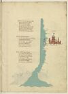
75r
p. 40/ f. 75r
¶ Quata Alexandria per ponente setta E guata a tramontana Satalia E terra richa nobil e perfecta E de gran porto di mercadantia Da indi e focie ove il nillo in mar getta Cinquanta miglia sum per drita via E chiamasi Ivi il fiume del rosseto Che sum trea millia miglia dal strecto
¶ Un’altra foce sença fare girata Piu su cinquanta miglia al mar dichina Passato quello trovi damiata Poi sum ducento miglia di marina Fin a larissa che -e- la piu ingolfata Che piu al mar rosso s’avicina E quivi da levante a tramontana Il lito gira e tuta terra piana
¶ Da larissa a laiaça d’ermenia Rita costiera sum miglia seicento Per tramontana tuta quella via In verso greco per quarta di vento Il porto di baruti di soria Nel meço sta a puocco a le trecento E quindi sono a ch'il pilglia Fino Alexandria cinquecento miglia
[image, right margin and lower margin: Map depicting a stretch of the Egyptian coast. Ocean painted aquamarine with wave pattern in grey. At ¶ 2: on a tributary extending rightwards sits a fortified city; above it, in red ink: (label: CHAIRO .); below it, in red ink: (label: chairo de babilonia). The city, tinted reddish-brown with blue roofs, includes a tower with a blue-and-white-striped dome from which flies a flag, yellow with crenelated edge, bearing: Escutcheon Azure overall a Moor’s head proper, couped, blindfolded Argent. At the mouth of the tributary, two islands: one outlined with a reddish-pink wash; the other painted blue with a white diamond marked /d/ in red ink, the remainder of its name—(label: damiata)—continuing on the nearby coast. Location names along the coastline, top to bottom, in red ink: (label: Larissa), (label: Rosseto), (label: alexandria), (label: Lucho).]
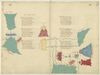
75v
p. 41/ f. 75v
¶ Larissa ha intorno stagni et almagalle Fra terra diserti insino al locho Dov’e la trista e ben punita valle Che vendicata fu da dio col fuocho Quivi e un alto monte e poi le spalle Del monte sinai piu la su un puocho Su qual fu data la legie divina Dov’e sepulta sancta chaterina
¶ Tra larissa e Baruti apunto in medio Evi porto de la terra sancta Che di colui doverebbe essere predio Che capo de christiani esser si vanta Dove quel digno Re tene'l suo sedio Che fesse l’opra ch’ogni di si canta Quel sancto sepulchro di ihesu La dove crucifixo per noi fu
¶ Syon e questo capo di iudea Verso levante un puocco a dextra mano E da sinistra mano e galilea E da levante sta il fiume giordano E aman rita siegue cesarea E achari surro saito e libano Monte donde esce il fiume di dui fonti Quive -e- carmelie altri sancti monti
[image, lower margin: Map depicting the coast of the Holy Land from Tarsus in Asia Minor to the Sinai Peninsula—the water painted aquamarine with grey waves; the coastline heightened yellow—with cities marked in red ink and Jerusalem depicted as a reddish brown city with blue domes topped by crossestinted yellow. Underneath the city of Jerusalem sits a crenelated tower in reddish-brown topped by a single blue dome. Placenames, clockwise from left, in red ink: (label: Tarso), (label: laiaccia), (label: Alexandria), (label: Soldino), (label: lalecia), (label: Tortossa), (label: tripoli de Soria), (label: Baruti), (label: Saitto), (label: Surio), (label: Acri), (label: Cesarea), (label: Jerusalem), (label: giazara), (label: Giaffa), (label: Larissa).]