Pages That Mention bona
Kenneth Spencer Research Library, Pryce MS P4 Place Names Identified

Page 41
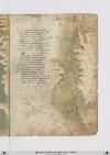
P. 41 Guide letter: d] [D]Affrica ad capulia et ad faciesse Son molte secche dallito rimote E che vol navichare indi ad capessie Fra esse ellito per canal si puote Et seguon poi fine ad rasamabesse Ma qui bisognia che di fuori si rote Da tunisi insin qui per maestraele Trecento miglia son per diricto strale [Guide letter: p] [P]oi tripoli cicta di barbaria Centovinticinque verlevante E misurata fu per quella via Duciento miglia et due volte altre tante Fo et sonno fino ad rauseni per traversa Dove fa un capo il monte achalante Lasciando uno golfo ove ad man dricta Çamara et poi bernicho et tholomecta [Guide letter: e] [E]chi girasse il golfo per costea Barrebon piu delle miglia duciento Dal capo di rausem abon andrea Son ciento miglia pur per drecto vento Lucho piu su duciento par che stea Indi Allexandria aquactro ciento Che quasi in mezo dessa sta larassa Et e/ questo paese terra bassa
Right margin, a portolan-style map drawn in brown ink and oriented with East at the top representing, counterclockwise starting at the top: 1) the western tip of Sicily (label: cecilia) colored red; 2) the southern tip of Sardinia (label: sardenga), with land coastline lightly shaded brown; and 3) the northern coast of Tunisia and Algeria, the seacoast lightly shaded in green, and with the following places labeled, from the top and counterclockwise down the coast: Africa (label: affrica), [Gabes?] (label: Papae), Cape Bon/Ras ed-Dar (label: capo bono), Tunis (label: tunigi.), Bizerte (label: biserta.), Tabarka (label: tabarta.), Annaba (label: bona.), Stora (label: storia.), [?] (label: angolo.), [?] (label: zizari.), Béjaïa (label: bugea.), Dellys (label: titelis), Algiers (label: algeri).
Vat.lat.7612 Place names identified
20r
P. 39 Indi adbuggiea sonmiglia ciento venti pur trallevanta egrecho eposccia ebona piu su dugiento pur perdetti venti eluna elaltra cipta siragiona dayvi aciento miglia poi seghuenti truovi biserti esecondo chesuona performa quivi presso fu chartagine lagrande esene vede alchuna ymagine
Tunisi fapiu la suo residenza sesantta miglia edun gran gholfo aporto laqual citta sighuarda chon fiorenza aduno occhaso quasi edunorto capo direngno ede digram potenza eben dotata terra enon atorto chelle nelmezzo dillabarberia presso aitalia piu chaltra visia
Sta con Jerusalem econsibilia inclinati dacuro edazaffiro esta vicina perdugiento miglia alleduo maggiorisole digiro lequali sono lasardingna ellascicilia quasi intriangholo quando ben vimiro africha stapo[i] vermeridiano passato capo bono adestra manno
[Image: Right margin, a map of the Mediterranean Sea including (on left) the southern tip of Sardinia (label: SARDIGNIA), then from top to bottom (east to west) at right, the western tip of Sicily (label: Sicilia), and the North African coast: (label: Sussa), (label: Cartagi), (label: bona), (label: Tuniçi), (label: biserti), (label: Bona) again, (label: Storia), (label: bugea) with a small image of a walled city, (label: titelis) (modern Dellys, Algeria), and (label: Algieri). The Mediterranean is colored in a grey-green wash.]
BnF. Bibliothèque de l'Arsenal. Ms-8536
74v
p. 39/ f. 74v
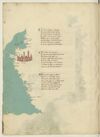
¶ D'africa a chapolia ad a facesse Sum molte seche da lato remote E chi vol navicar indi a chapesse Fra epsi -e- litto per canal si puote E seguen poi fin a rassa mabesse Ma qui bisogna che de fuora sia ruote Da tunis insin qui per maestrale Trecento miglia sum per dritto strale.
¶ Poi tripoli cita de barbaria Cinquanta cinque miglia inver levante E misurata su per quella via Ducento miglia e duo volte atretante Sum fin a rusen per traversia Dove fa capo il gran monte athalante Lassando uno golfo ov'e a man drita Çianarra e poi Sernich e tholomita
¶ E chi girasse il golfo per costiera Serebon piu de le miglia ducento Dal cavo di rausem a bonandria Sum cento miglia pur per dricto vento Lucho piu su ducento par che stia E indi ad Alexandria a quatro cento E quasi in meço d'epse sta la rassa E questo paese -e- terra bassa
[image, left margin: Map with east at the top depicting a stretch of the Algerian and Tunisian coasts up to the Gulf of Gabes with Kerkennah Islands and Djerba. Ocean painted aquamarine with wave pattern in grey; the coastline heightened yellow. At top, three islands are in a darker green. Near ¶ 2 there is a a reddish-brown city with blue domes and spires. Placenames: in the water, close to the first two islands, in red ink, vertically, (label: cherchani). On the mainland, in red ink, from the top down: (label: Ixola de gierbi), (label: Caps), (label: fachse), (label: susa); in black ink, (label: cavo bono). The city is named as (label: Tunis.); further names, continuing down the coast, in red ink: (label: Cartagine), (label: biserto), (label: Bona), (label: angholo), (label: Bugiea), (label: algieri).]