Pages That Mention barbaria
Kenneth Spencer Research Library, Pryce MS P4 Place Names Identified

Page 41
P. 41 Guide letter: d] [D]Affrica ad capulia et ad faciesse Son molte secche dallito rimote E che vol navichare indi ad capessie Fra esse ellito per canal si puote Et seguon poi fine ad rasamabesse Ma qui bisognia che di fuori si rote Da tunisi insin qui per maestraele Trecento miglia son per diricto strale [Guide letter: p] [P]oi tripoli cicta di barbaria Centovinticinque verlevante E misurata fu per quella via Duciento miglia et due volte altre tante Fo et sonno fino ad rauseni per traversa Dove fa un capo il monte achalante Lasciando uno golfo ove ad man dricta Çamara et poi bernicho et tholomecta [Guide letter: e] [E]chi girasse il golfo per costea Barrebon piu delle miglia duciento Dal capo di rausem abon andrea Son ciento miglia pur per drecto vento Lucho piu su duciento par che stea Indi Allexandria aquactro ciento Che quasi in mezo dessa sta larassa Et e/ questo paese terra bassa
Right margin, a portolan-style map drawn in brown ink and oriented with East at the top representing, counterclockwise starting at the top: 1) the western tip of Sicily (label: cecilia) colored red; 2) the southern tip of Sardinia (label: sardenga), with land coastline lightly shaded brown; and 3) the northern coast of Tunisia and Algeria, the seacoast lightly shaded in green, and with the following places labeled, from the top and counterclockwise down the coast: Africa (label: affrica), [Gabes?] (label: Papae), Cape Bon/Ras ed-Dar (label: capo bono), Tunis (label: tunigi.), Bizerte (label: biserta.), Tabarka (label: tabarta.), Annaba (label: bona.), Stora (label: storia.), [?] (label: angolo.), [?] (label: zizari.), Béjaïa (label: bugea.), Dellys (label: titelis), Algiers (label: algeri).
BnF. Bibliothèque de l'Arsenal. Ms-8536
74r
p. 38/ f. 74r
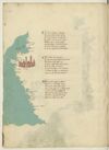
¶ Indi algieri son miglia cento vinti Tra levante e grecco e posta bona Piu su ducento pur per dicti venti E l'una e l'altra cita si ragiona Da Ivi a cento trenta poi seguenti Trovi misserti che secondo che se rasona Per fama quivi presso fu carthagine La grande e si se vede alcuna ymagine
¶ Tunis fa piu la su residentia Sexanta miglia e d'un gran golfo ha porto La qual cita si guata cum firencia Ad un occasso on quasi ad un horto Capo di regno e di gran potentia E ben doctata terra e none a torto Ch'ella -e- nel meço de la barbaria E presso a Italia piu ch'altra vi sia
¶ Sta cum ierusalem e cum sibilla Inclinati da choro e da çephiro E sta vicina per ducento miglia A le due magior insule de giro Le qual sum la sardegna e la cicilia Quasi in triangulo quando ben vi miro Africa sta poi ver merediano Passato cavo bono a dextra mano
[image, from top down left margin and across bas de page: Map depicting a stretch of the Tunisian coasts and Libyan coasts from Cape Bon (Tunis) to the Gulf of Sidra with the Kerkennah Islands and Djerba. Ocean painted aquamarine with wave pattern in grey. On gutter-side shore, at ¶ 2: a fortified city in reddish-brown with blue roofs. Atop water at ¶ 1: three islands in green; on the water nearby, in red ink (label: cherchani). In top margin, inverted, in black ink: (label: Cavo bono). In left margin, from top downwards, in red ink: (label: Susa), (label: africa), (label: fachse), (label: Caps), (label: ixola di gervi), (label: rasamabes), (label: tripoli di barbaria .), and (inverted) (label: misurata). Bas de page, from left clockwise, in red ink: (label: Çianara), (label: Brinch), (label: Tolometa); in black ink: (label: Cavo de rausem); in red ink: (label: bonandrea), (label: luco).]
[image, right margin at ¶ 2: Map of an island, tinted green with rivers indicated by waving blue lines. Written vertically, in red ink (left to right): (label: mesina), (label: Ixola de cicilia).]
[image, right margin at ¶ 3: Map of an island, tinted pink, within a small patch of water painted aquamarine with wave pattern in grey. Upon the island, in black ink: (label: Ixola di sardigna); also on the island, above this, in red ink, inverted: (label: Calici).]
74v
p. 39/ f. 74v
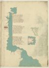
¶ D'africa a chapolia ad a facesse Sum molte seche da lato remote E chi vol navicar indi a chapesse Fra epsi -e- litto per canal si puote E seguen poi fin a rassa mabesse Ma qui bisogna che de fuora sia ruote Da tunis insin qui per maestrale Trecento miglia sum per dritto strale.
¶ Poi tripoli cita de barbaria Cinquanta cinque miglia inver levante E misurata su per quella via Ducento miglia e duo volte atretante Sum fin a rusen per traversia Dove fa capo il gran monte athalante Lassando uno golfo ov'e a man drita Çianarra e poi Sernich e tholomita
¶ E chi girasse il golfo per costiera Serebon piu de le miglia ducento Dal cavo di rausem a bonandria Sum cento miglia pur per dricto vento Lucho piu su ducento par che stia E indi ad Alexandria a quatro cento E quasi in meço d'epse sta la rassa E questo paese -e- terra bassa
[image, left margin: Map with east at the top depicting a stretch of the Algerian and Tunisian coasts up to the Gulf of Gabes with Kerkennah Islands and Djerba. Ocean painted aquamarine with wave pattern in grey; the coastline heightened yellow. At top, three islands are in a darker green. Near ¶ 2 there is a a reddish-brown city with blue domes and spires. Placenames: in the water, close to the first two islands, in red ink, vertically, (label: cherchani). On the mainland, in red ink, from the top down: (label: Ixola de gierbi), (label: Caps), (label: fachse), (label: susa); in black ink, (label: cavo bono). The city is named as (label: Tunis.); further names, continuing down the coast, in red ink: (label: Cartagine), (label: biserto), (label: Bona), (label: angholo), (label: Bugiea), (label: algieri).]