Pages That Mention zamor
Kenneth Spencer Research Library, Pryce MS P4 Place Names Identified

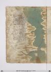
Page 39
P. 39 Incominciando dal meridionale Lito dil mare isula strecta boccha Che miglia sedici e/ largo il canale Et ha da omne parte mon[ti?] e rocha Sta la cicta disecta la qual sale Sei giorni al greco sopra amorocha Elaltre tanto edirimpecto ad essa Per meçço della gran cipta difessa Disocto ad secta forse mille miglia Giu per quellito poca sa noticia Dandarvi aluomo di rado si consiglia Ne perdilecto ne per avaricia Egia nefuron che per maraveglia Vollon passare piu oltre e/ contristicia Dilor et dilor genti fo tal gita Che mai poi non si seppe dilor vita In queste mille miglia di marina Verso lobeccio trovi prima arcilla Et poi la raggia le assai Vicina Sale poi segue che Unabona villa Un fiume che allato li confina Che dal monte athalante sidistilla Per meço fessa passa e concinquanta Miglia ha insinla et adsecta altre tanta
Inland, top to bottom, are three cities symbolized by towers within city walls (colored red and gray): Rabat (label: rabat) by one small tower on an island in the river, Fes (label: fessa) by 11 large towers, and Marrakesh (label: morocho) by three towers. Seaports named along the Moroccan coast from the Straits of Gilbraltar at the top to the Canary Islands at the bottom, are: Ceuta (label: setta), Asilah (label: arzilla), Larache (label: laracha), Salé (label: sala), Anase (label: nisse), Azemmour (label: zamor), Safi (label: saffi), Gazola (label: gazola), and Messa (label: messa). Four Canary islands shown colored with flat washes are: Lanzarote (label: lanciletto) in red, Fuerteventura (label: formentario) in light brown, Gran Canaria (label: knaria) in red, and Tenerife (label: delinforno) in light brown.]
Vat.lat.7612 Place names identified
19v
P. 38 Niffe zamor saffi ghazola emessa una dopo laltra cinquanta inottanta miglia si truova poy dila daessa epiu oltre nonpare chenascha pianta nechessitruovi senon rena spessa cierchando lariviera tutta quanta veggiono daterra piu isole imare canaria ealtre dipoccolo affare
Seghuendo illito verso loriente treciento miglia sta hone insalmare disopra asetta andando colponente echi atremisen volessi andare fraterra atre giornate oquasimente one chonchartagine sta delpare afar pileggio chonvento africhone dugiento otanta miglia adacquilone
Poy trallevante egrecho sta horano piu alto cientomiglia insuquellito lacipta ditenes per quella mano piu su cientocinquanta tiensuo sito epoccho piu diciento dilontano quella dalgieri laquale diriza ildito adacquamorta verso tramontana questo paese apocha terra piana
[Image: Left and lower margins, a map of the coast of Spain and north Africa from Gibraltar to Cartagena and Algiers. The large body of water (label: Mare mediterano) is painted in grey-green with a wave pattern in a light brown. In the (label: Mare di Spagnia) there is an unlabeled island, representing Majorca, which has been painted with a few strokes of red. A scribal (note: Ro[sso]) calling for red is visible at the top of the island.
Many cities and regions are labelled. On the left/European side, top to bottom: (label: Cartagena), (label: Almeria), (label: Saruignia), (label: Granata), (label: Lisbona), (label: Spagnia), (label: Indi), (label: Sibilia). On the right/African side: (label: Algieri), (label: Brescia), (label: Mestegani), (label: Arçeu), (label: Orano), (label: Seren), (label: One), (label: Melina). All are in red ink except for "Indi" (?) in black.]