Pages That Mention Cape of Good Hope (South Africa)
Abstract log of the E. I. Ship Clarence, 1864-1891.
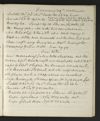
p. 91
January 29th continued
Latde [Latitude] obsd [observed] 35.56 So Londe [Longitude] Chr [Chronometer] 23.24 East Course S 55 W 145 miles Cape Agulhas N 69 W 183 miles Cape of Good Hope N 69 W 263 miles Bar [Barometer] 29.62 Sympr [Sympiesometer] 29.58 Ther [Thermometer] air 74 water 76 PM Heavy gales at NW with hard squalls & rain. at 1 Wore ship to the Nd [Northward] at 5 wind veering to West & a little more moderate set the Fore Top sail close reefd [reefed] very heave sea a Westd [Westward] Midnight decreasing gale at WSW Bar [Barometer] 29.94
Jan [January] 30th
am decreasing gales at WSW & less sea set the Mizen [Mizzen] Topsl [Topsail] double reefd [reefed] at daylight out 3rd & 2nd reefs of Topsls [Topsails] shifted the foresail & made sail at 8 Moderate SW wind out all reefs & made all plain sail. a ship ahead as ourselves. Noon moderate SW wind & fine Wr [weather] high swell left Latde [Latitude] obsd [observed] 35.14 So Londe [Longitude] Chr [Chronometer] 21.38 E Course N 64 W 96 1/2 miles Bar [Barometer] 30.23 Sympr [Sympiesometer] 30.22 Ther [Thermometer] air 68 water 70 Cape Agulhas N 74 W 82 miles dist [distance] Cape of Good Hope N 71 W 163 miles [ditto]

p. 92
January 30th continued
PM Light SW wind & fine at 2 Passed & signalled the English ship 3rd pt [point?] 9241 + [cross with four dots] from Calcutta to London 63 days out. at 9 Light breeze veering to SEd [SEastward] & fine clear Wr [weather] 5 1/2 knots
January 31st + [cross with four dots] French Empire
am Light wind at ESE & fine Increasd [Increased] set the starbd [starboard] studg [studding] sls [sails] at 5 saw the land about Cape Agulhas bearing North. The breeze un- steady at East to NE & Increasing at 8 Quorin Point N b E 3/4 E Noon Fresh breeze at SE & fine set all the Port studg [studding] sls [sails] Cape Hangklip N by E 1/4 E Danger Point E by S. Latde [Latitude] obs [observed] 34.47 So Londe [Longitude] Chr [Chronometer] 19.06 E Course N 77 W 128 miles Cape of Good Hope N 37 W 31 miles Bar [Barometer] 30.18 Sympr [Sympiesometer] 30.14 Ther [Thermometer] air 72 water 71 PM Strong wind at S by E ship sailing 12 knots at 2.30 Table mountain NE by N & Cape of Good Hope Light House NNE 1/2 E at 5.30 Table Mountain E 3/4 S Midnight steady strong wind at S by E & fine carrying the Port studg [studdings] sls [sails] & Main Skysail ship sailing 13 knots.
William B. Hadden diary, 1865.
p. 18
Lat Longde
[?] Island of Rodrigue lies in 19o-41'-o". 63-201-0"
[?] Island lies in 20-9-0. 75-28-41
Cape of Good Hope lies in 34-[illegible?]-24
[St Helena?] lies in 15-54-48. 5-45-20
[?] lies in 36-6-20. 5-20-53
Cape St. [?] lies in 37-2 54. 9-0-54
Calcutta lies in 22-34-38. 88-21-12
Bombay lies in 15-55-48. 72-52-54
[?] near Kurrachee lies in 22-24-0. 70-56-30