Pages
72 EXPLANATION OF THE MAPS.
and may serve as a guide to the tourist in this interesting district.
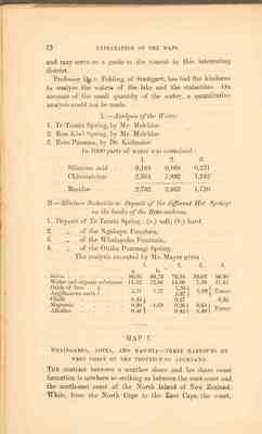
Professor Dr. v. Fehling, of Stuttgard, has had the kindness to analyse the waters of the lake and stalactites. On account of the small quantity of the water, a quantitative analysis could bot be made.
A. -- Analysis of the Water. 1. Te Tarata Spring, by Mr. Melchior. 2. Rua Kiwi Spring, by Mr. Melchior. 3. Roto Punamu, by Dr. Kielmaier.
In 1000 parts of water was contained :
| 1. | 2. | 3. | |
|---|---|---|---|
| Siliceous acid | 0,164 | 0,168 | 0,231 |
| Chlornatrium | 2,504 | 1,992 | 1,192 |
| Residue | 2,732 | 2,462 | 1,726 |
The analysis executed by Mr. Mayer gives :
| --- | 1. | 2. | 3. | 4. | |
|---|---|---|---|---|---|
| a. | b. | ||||
| Silica | 86,03 | 84,78 | 79,34 | 88,02 | 86,80 |
| Water and organic substance | 11,52 | 12,86 | 14,50 | 7,99 | 11,61 |
| Oxide of Iron } | 1,21 | 1,27 | 1,34 } | 2,99 } | Traces |
| Argillaceous earth } | 3,87 } | ||||
| Chalk | 0,45 } | 0,27 | 0,36 | ||
| Magnesia | 0,40 } | 1,09 | 0,26 } | 0,64 | Traces |
| Alkalies | 0,38 | 0,42 } | 0,40 } |
The contrast between a weather shore and lee shore coast formation is nowhere so striking as between the west coast and the north-east coast of the North Island of New Zealand. While, from the North Cape to the East Cape, the coast,
EXPLANATION OF THE MAPS. 73
sheltered from the prevailing winds, presents a most irregular outline, forming deep in the land many indented harbours navigable by the largest ships- for example, the Bay of Islands and the Waitemata or Auckland harbour- with numerous islands and capes; the West Coast, which is exosed to the westerly wind, is, on the other hand, from Cape Maria Van Diemen to Cape Egmont, an almost regular outline, slightly curved towards the east, and is formed by a nearly uninterrupted chain of sandbanks. These sandbanks in many places, and particularly where there is no steep or higher rocky coast in the background, reach a height of 500 to 600 feet, and when seen from the sea, appear like a chain of mountains. The bays and de creeks of the West Coast are, in consequence of these sandbanks, locked up from the sea, and are merely estuaries, navigable only through narrow entrances, in which the sea ebbs and flows. At high water these estuaries appear like large lakes, but at low water immense mud flats, intersected by narrow channels, are laid bare. On the West Coast are six of these estuaries, three north of the Waikato- the Manikau, Kaipara, and Hokianga harbours; and three south - the Whaingaroa , Aotea, and Kawhia harbours. All these estuaries have this in common - that the sandbanks which are situated before their entrances, are continually shifting thei situation before their entrances, are continually shifting their situation and form. This is most prejudicial to navigation, and in consequence all these harbours, with the exception of the Manukau, which alone is navigable by larger vessels, are only available for small coasters. The most suthern of the harbours - Aotea and Kawhia - are represented on this map. The Whaingaroa harbour is a small sea inlet, six to seven miles long, branching off in many directions, and divided into two parts by a long peninsula. Into the northern bay flows the Whaingaroa river, and into the southern the Waitetuna. The harbour is only navigable for vessels from 60 to 80 tons, which generally anchor near the outlet; but by boats it is possible to keep up a communication with the most remote branches. At low water the harbour is almost empty; large mud flats are exposed, the narrow channels only retaning water. The Maori population of the neighbourhood amounts
This page is not transcribed, please help transcribe this page
This page is not transcribed, please help transcribe this page
76 EXPLANATION OF THE MAPS.
Limestone which appear at the Aotea and Whaingaroa Harbours appear also at the northern bank of the Waiharakeke River, forming the border walls and distributed in almost horizontal strata over the whole south-eastern side to the Awaroa River. At the Rakaunui River these chalk banks reach to the water's edge, and form along the coast the most picturesque rocks in the shape of towers and ruins, in consequence of which this part of the Kawhia Harbour has been designated the New Zealand Switzerland. The romantic and various shapes assumed by the town and worn masses of rocks surprises the eye everywhere, while int he valleys, where lie the villages of the natives, the rich fields of corn and maize delight the beholder. I consider this as one of the most beautiful and fertile districts of New Zealand which I have seen. The character of the landscape remains the same far up into the mountains, and 1000 feet above the harbour white masses of rock penetrate through the verdure of the forest and bush. Hence the name of Castle Hills for these mountains, which the natives cal Whenuapu. This Neighbourhood also possesses numerous caves. This limestone formation appears also on the north side of the Kawhia Harbour, in the Towara Bay, and on the Puti Riber; it is rich in large oysters and terebratulae. The east side of the habour consists partly of scattered volcanic tufa and conglomerate, which are connected with the trachy-dolerite chain of Pirongia. Over these mountains, paths thickly covered with bush lead inwards to the Waipa valley.