Pages That Need Review
Butler Diary: Northern and Central Syria IV, 1900
BSY_FB_16-02
2
Northern Syria
If we take the city of Ḥannu as the dividing line between Northern and Central Syria it will give a convenient limit for the rough geographical distribution of the archeological remains as we study them. This division will correspond approximately with that made by de Vogüé and will coincide very nearly with the present governmental line of demarkation between the Wilayet of Damascus and that of [Haleb]
So far as they have been pursued, our studies of the architecture and inscriptions of these two districts show interesting differences, which will appear the more striking when we have made a careful comparative study of the remains in the mountain districts of the north with those of the central plains.
BSY_FB_16-03
3
Djisr il Madjdal March 15, 1900
After leaving Ḥama about two and a half hours to the north west, just south of a small village called Mudjdal, we crossed an ancient Roman bridge which has taken its name from the neigbouring village.
The bridge crosses an arm of the Orontes not very far from its junction with the larger stream. The stream was at its full height when we crossed it owing to continued rains and we could see that there is never sufficient water in the stream to endanger the safety of the old bridge, while all the ancient bridges over the Orontes have long since been swept away.
The bridge is preserved in its ancient form almost entire, four large round arches of equal dimentions, spanning about six metres, are in place, only the solid approaches at either end seem to have been repaired in Saracenic masonry.
BSY_FB_16-04
4
The road way which is 5m. 60cm wide preserves a considerable amount of original pavement in large rectangular slabs - this seems to have been laid at the ^ level ^ of the crowns of the voussoir of the arches. This paving can be traced at intervals for a distance of 47 paces which corresponds to the length of the preserved portions of the substructure.
The whole bridge is constructed in excellent Roman style of large oblong blocks laid without mortar. On the upper or southern side are traces of an angular abutment, now buried in the mud and concealed further by the high water.
After crossing the bridge we ascended the hill and after passing near the eastside of the village at the top of the hill found traces of the ancient road cut in the natural rock and just beyond, on a slight eminence, some heavy ancient foundations which doubtless mark the site of an old Roman watch tower.
One can see that the peasants are still excavating at this spot for building stones.
BSY_FB_16-05
5
Ḳalʿat Sêdjar (Larissa) March 16, 1900
The site of ancient Larissa situated on a curve of the Orontes where the river comes through a narrow rocky gorge and flows out into the plain preserves few traces of the Greco-Roman city.
The acropolis is occupied by the ruins of a Saracenic castle and a squalid modern village it occupies the abrupt end of a rocky ridge and was cut off from the ridge by a broad deep moat excavated in the rock on the south. To the east the rock falls steeply to the river. To the north and west it decends to the plain. The whole acropolis was surrounded by a heavy wall the foundations of which are doubtless in situ. It was reached in ancient times by a bridge over the moat in the south as it is today tho' the present bridge is Saracenic. The late ruins are full of classic fragments - columns, caps bases and lots of decoration. The caps are Corinthian & Ionic.
In the plain are traces of a wall which enclosed the lower city and the surface is shown with ancient architectural fragments.
BSY_FB_16-06
6
Ḳalʿat il Muḍîḳ (Apamea) March 17&18th, 1900
From Ḳalʿat Sêdjar we moved the camp northward, crossing the river just below the town and travelling over the rolling downs of the river valley about four hours toward the Southern foothills of the Djebel. Here is situated the ruin of a great Saracenic castle upon the acropolis of the ancient city of the Seleuicid kings. The ruin is now occupied by a large and filthy village.
The acropolis rises directly from a great marsh which was once a lake. From either side of the acropolis begin the walls of the lower city which run to the North and South and then turn eastward to enclose an enormous area.
The walls are easily traceable throughout this entire length, parts of them have been rebuilt by the Saracens but in a number of places the ancient stonework, of excellent character, is still in situ. Toward the East and South a deep narrow valley forms a natural moat below the walls but toward the north the country is level.
BSY_FB_16-07
7
Remains of a great gate are to be found in the southwall and in the north. The former was reached by a broad roadway ascending from the valley along the slope below the wall. There were two gates in the East wall.
A great double colonnade ran through the city connecting the North and South gates. This was bisected by two similar colonnades connecting with the two east gates.
On the west of the great colonnade, nearer the north gate then the south, are the remains of a great public building, in all directions are ruins of other large buildings all in late classic style. Just south of the acropolis, on the opposite slope, above the avenue which led down to the lake, are the remains of a great vaulted substructure with ornamental pilasters and cornice on the side.
Upon the acropolis there are no remains of antiquity but the foundations of great walls and a quantity of fragments of capitals, columns, architraves and inscriptions
BSY_FB_16-08
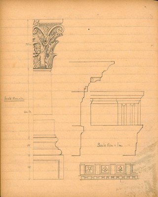
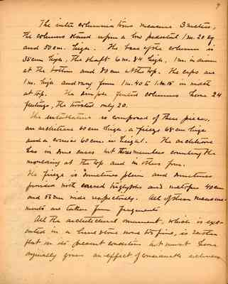
8
Great Colonnade - From the south gate of the city to the north gate this great avenue of columns bisected the city. Two colonnaded avenues joined this main one, running from the two east gates and probably, carried through toward the acropolis at the west, tho' all remains of these portions on the west of the main colonnade are missing. The main colonnade was once a mile in length. The avenue was a little over 21 meters wide between the columns.
The order of the colonnade is Roman Corinthian from one end to the other. The only perceptible variation being in the shapes, of which there are three kinds, plain, fluted and twisted.
A minute examintion however shows that some parts of the work are better executed than others. Behind the colonnade ran a solid wall broken at intervals for entrance to streets. At these points was a broad spacing of the columns. From the columns to the wall a continuous gabled roof covered the colonnade. No portion of this great structure is standing ^ over ^ six feet above the present level but it is not difficult to restore it.
BSY_FB_16-08a
Details from Great Colonnade, including rendering of a Corinthan capital and profile of the entablature.
Scale 5cm = 1 m.
BSY_FB_16-09
9
The inter columnations measure 3 metres, the columns stand upon a low pedestal of 1m 20 sq and 50cm high. The base of the column is 35cm high. The shaft 6m 84 high, 1m in diam at the bottom and 80cm at the top. The caps are 1m. high and range from 1m. 40 to 1.m. 15 in width at top. The simple fluted columns have 24 flutings, the twisted only 20.
The entablature is composed of three pieces, an architrave 60cm high, a frieze 68cm high, and a cornice 60cm in height. The architrave has in some cases but three members counting the moulding at the top and in other form.
The frieze is sometimes plain and sometimes provided with carved triglyphs and metopes 40cm and 53cm wide respectively. All of these measurements are taken from fragments.
All the architectural ornament, which is executed in a limestone none too fine, is rather flat in its present condition but must have originally given an effect of considerable richness
BSY_FB_16-09a
from bottom of p. 10
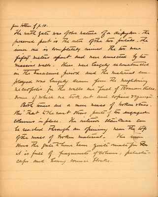
The north gate was of the nature of a dipylon. The preserved part is the outer of the two portals. The inner one is completely ruined. The two were fifty meters apart and were connected by two massive walls. These were largely reconstructed in the Saracenic period and the material employed was largely drawn from the neighboring necropolis for the walls are full of Roman stelae, some of which we took out and copied and squeezed.
Both towers are a mere mass of broken stones. tho' that to the east shows parts of two engaged columns in place. The interior staircase can be reached through an opening near the top of the mass of broken material. The ruin shows the gate to have been quite ornate for it is full of fragments of columns, pilasters, caps and heavy cornice blocks.