Pages
[30 Oct 1712]
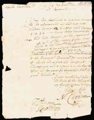
North Carolina// By the Hon.ble the Governour and Counsile—
You are forth with to measure or cause to be admeasured and Laid out unto William Browns Tracts of Land Conteyning 1 to 80 — acres being due unto the Said Wm Brown for the payment of 2[S]—6d for every fifty acres payed to the Honble the Governour— pursuant to an order of Councele Dated November 5th 1705—
Observing the Lords proprietors Instructions to the Surveyor Generall for r[illegible]ing out of Lands and a plat and Certificat — Thereof you are to return into the Secretary Office and for your So doing this shall be your Warrant.
Given under our hand and Seale of the Collony this 17 day of May anno Dom 1712
Edward Hyde N: Chevin J Peterson T: Knight Wm Rood
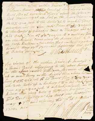
By virtue of the within Warrant [illegible] William Brown [illegible] a Tract of Land Lying on the South Side of [illegible] Lived above the (Toteran?) Fort Beginning at an Ash on the River Thence -- So. 15 E 320 pole to the center of 3 marked Trees one white and too Live oaks. Then No 75 [?] 320 pole to the Center 3 marked Trees 2 Hickroys and a Red Oak Then No. 15 W. 320 pole to a mulberry Tree on the River. Thence along the River Banck to the first Station. The above Tract contayns 640 acres surveyd May 17th 1712 and returned this 30th of October 1712 per William [illegible]
By virtue of the within Warrant Surveyd a Second Tract adjoyning to the above Survey for the above named William Brown [illegible] at a mullberry on the River then along his own Line S 15 E 320 pole to his own corner then No. 15 W 320 -- pole to the Center of 2 hickroys & a red oak Saplin then N 15 W 320 pole to a Black Walnute on the River then along Ditto to the first Station -- this Tract Contoyns 640 acres was Surveyd -- May 7th and returned thiss 30th of October 1712 per [illegible signature]

[30 October 1712] North Carolina ss: By the Hon.ble the Governour and Councile
You are forthwith to measure or cause to be admeasured and laid out unto Wm. Brown Two Tracts of Land Containing 1280 acres being due unto the said Wm Brown for the paymt of [illegible] for every [illegible] acres payed to the Honble the {Governour?] persuant to an order of [Counsil?][illegible] [illegible] Observing the Lords Proprietory Instruction to the Surveyr Generall for funing out of Lands and a Plat & Certificate thereof you are to return into the Secretarys Office and for your so doing this shall be your Warrant.
Given under our hand and Seal of this Collony this 7th day of Anno Dom 1712
Edward Hyde Wm Rood N Chevin J [Pehnron?] G. Knight
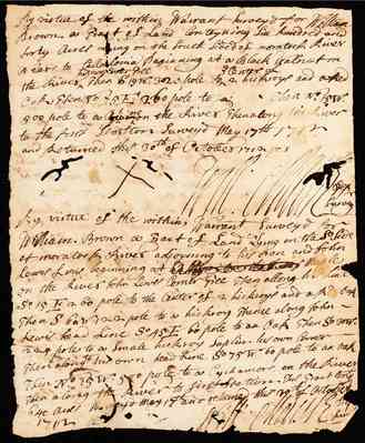
By virtue of the within Warrant Surveyd for William Brown a Tract of Land Contayning Six hundred and forty acres Lying on the South Sided of moratock River Neare to Callaloma Beginning at a Black Walnut on the River his own corner tree then S 15 W 320 pole to the Center of 2 hickroys and a Red Oak, then No. 75 E. 260 pole to a [ ] Then No. 15 W. 500 pole to a Cyckamore on the River then along the River to the first Station Surveyd May17th1712 and Returned this 30th of October, 1712 per
X Wm. [illegible]
By virtue of the within Warrant Surveyd for William Brown a Tract of Land Lying on the So. Side of moratock River adjoyning to his own and John Lewis Lines beginning at A [illegible] maple on the River John Lewis Corner Tree Then allong his line So. 15 E 260 pole to the Center of 2 hickroys and a Red Oak Then S 60 W 120 pole to a hickroy Thence along John Lewis head Line So 45 E 60 pole to an Oak then So 30 W. (224?) pole to a Small hickroy Saplin his own Corner -- Then along to his own head Line So 75 W 60 pole to an Oak Then No. 15 W. 500 pole to a Cyckamore on the River then along the River to first Station. This Tract con 640 acres Surveyd May 17th and Returned this 30th of October 1712. [illegible]
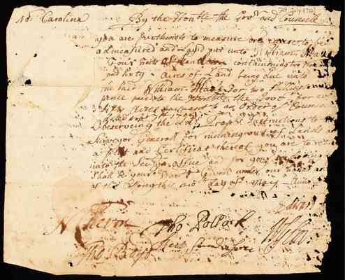
[29 July 1712] No. Carolina By the Hon.ble the Govr and Counisle you are furthwith to measure or cause to be admeasured and Layid out unto William [illegible] Four Tracts of Land containening two [thousand?] and sixty acres of Land being due unto the Said William [illegible] for two shillings pence paid to the Honble the Good for each fifty acres pursuant to an Order of [Counstable?] dated Novbr [illegible] [1709] [illegible] Observeing the Lds Prosls Instructions to Surveyor Generall for running out of Lands and a plat and Certificat thereof you are to return into the Sec.y office and for your so doeing shall be your Warrant Given under our hand and of the Colloney this 20th day of May - Anno Do Edward [illegible] N Chevin Tho. Pollark Tho. Boyd Neil [illegible]