Pages
73r
p. 36/ f. 73r
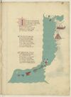
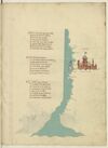
INcominciando dal meridionale Litto del mare in su la strecta bocha Che miglia sedece e largo il canale E d'ogni parte monti e rocha Sta la cita de seta la qual sale Sei giorni a greco di sopra a manrocha Ed altretanto e dirimpecto ad epsa Per meço de la gran cita di fessa
¶ Di soto a seta forsi a mille miglia Giu par quel litto s'a pocha notitia D'andarvi l'uno l'altro se consiglia Ne per dilecto ne per avaritia E gia ne furno che per maraviglia Volgion passar piu ultra e con tristitia Di lor e di lor gente far tal gita Che mai poi non si seppe di lor vita
¶ In queste mille miglia di marina Verso libecio trovi prima arcilla E poi larachale asai vicina Sala poi siegue che una bona villa Un fiume che al lato li confina Che dal monte athalante si distilla Per meço fessa passa e cencinquanta Miglia in sin la -e- da setta altretanta
[initial: Opening initial /I/, 4 lines, in blue with red pen flourishing heightened in yellow.]
[image, right margin and bas de page: Coastal map of north-western Africa and part of south-west Spain. Ocean painted aquamarine with wave pattern in grey. At top, two small islands, both painted red. In right margin, across from ¶ 1–¶ 2: a fortified city in reddish-brown with blue roofs; below this, a tower in reddish-brown with a blue-and-white striped dome. Bas de page, curving up towards the right margin, a chain of larger islands—the seven islands of the Canaries—painted (left to right): yellow, pinkish-red, blue, red, grey, grey-green, and white with a red cross (i.e. cross of St George), the last of these surrounded by five tiny islets in red. City names, in red ink, from top of page downwards: (label: Sibilia), (label: Cades), (label: Setta), (label: Arcilla), (label: laracha), (label: sala), (label: fessa), (label: niffe), (label: giamor), (label: marocha), (label: saffi), (label: gaziolla), (label: messa). Bas de page, also in red ink, on the waters adjacent to the Canaries: (label: camariam).]
73v
p. 37/ f. 73v
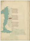
¶ Niffe çiamor gaçiola e messa Una doppo l'altra cinquanta e octanta Miglia si trova poi di la da essa E piu oltra non par che nasca pianta Ne che se trovi se non rena spessa Cercando la riviera tuta quanta Vegion da terra piu insule in mare Channariam e- altri di picolo afare
¶ Seguendo il lito verso l'oriente Trecento miglia sta hone sul mare Di sopra setta andando col ponente E chi a tremissen volesse andare Fra terra e tre giornate e quasimente Hone cum carthagine sta del pare Affar pilegio con vento affricone Ducento trenta miglia ad aquilone
¶ Poi tra levante e greco sta orano Piu alto cento miglia in su quel litto La cita de tenes per quella mano Piu su cento cinquanta tien suo sito E puoco piu di cento di lontano Quella d'algeri la qual diricia il dicto Ad acqua morta verso tramontana Questo paese ha poca terra piana
[image, left margin: Map with east at the top depicting the northwestern coast of Africa, the Strait of Gibraltar, the southern coast of Spain, and the island of Majorca. The sea is painted aquamarine with wave pattern in grey; the coastline in grey with a yellow shadow. At top, an island in yellow and red stripes (the Pales of Aragon), a reddish-brown city with blue domes is near ¶2 on the right side of the sea. To the right of the sea, from the top downwards, in red ink: (label: Algieri), (label: Tenese), (label: Orano), (label: onne), (label: Tremisem), (label: Setta). In the water, written vertically, in red ink (label: Streto in Gibilterra). In left margin, from the bottom upwards, in red ink, text rotated 180°: (label: Cades), (label: Malades), (label: Sciavignia), (label: Ameria), (label: Cartagine), (label: Valencia). At the top of the sea, on the mainland, the island is identified in red ink as (label: Maiolica).]
74r
p. 38/ f. 74r
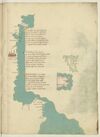
¶ Indi algieri son miglia cento vinti Tra levante e grecco e posta bona Piu su ducento pur per dicti venti E l'una e l'altra cita si ragiona Da Ivi a cento trenta poi seguenti Trovi misserti che secondo che se rasona Per fama quivi presso fu carthagine La grande e si se vede alcuna ymagine
¶ Tunis fa piu la su residentia Sexanta miglia e d'un gran golfo ha porto La qual cita si guata cum firencia Ad un occasso on quasi ad un horto Capo di regno e di gran potentia E ben doctata terra e none a torto Ch'ella -e- nel meço de la barbaria E presso a Italia piu ch'altra vi sia
¶ Sta cum ierusalem e cum sibilla Inclinati da choro e da çephiro E sta vicina per ducento miglia A le due magior insule de giro Le qual sum la sardegna e la cicilia Quasi in triangulo quando ben vi miro Africa sta poi ver merediano Passato cavo bono a dextra mano
[image, from top down left margin and across bas de page: Map depicting a stretch of the Tunisian coasts and Libyan coasts from Cape Bon (Tunis) to the Gulf of Sidra with the Kerkennah Islands and Djerba. Ocean painted aquamarine with wave pattern in grey. On gutter-side shore, at ¶ 2: a fortified city in reddish-brown with blue roofs. Atop water at ¶ 1: three islands in green; on the water nearby, in red ink (label: cherchani). In top margin, inverted, in black ink: (label: Cavo bono). In left margin, from top downwards, in red ink: (label: Susa), (label: africa), (label: fachse), (label: Caps), (label: ixola di gervi), (label: rasamabes), (label: tripoli di barbaria .), and (inverted) (label: misurata). Bas de page, from left clockwise, in red ink: (label: Çianara), (label: Brinch), (label: Tolometa); in black ink: (label: Cavo de rausem); in red ink: (label: bonandrea), (label: luco).]
[image, right margin at ¶ 2: Map of an island, tinted green with rivers indicated by waving blue lines. Written vertically, in red ink (left to right): (label: mesina), (label: Ixola de cicilia).]
[image, right margin at ¶ 3: Map of an island, tinted pink, within a small patch of water painted aquamarine with wave pattern in grey. Upon the island, in black ink: (label: Ixola di sardigna); also on the island, above this, in red ink, inverted: (label: Calici).]
74v
p. 39/ f. 74v
¶ D'africa a chapolia ad a facesse Sum molte seche da lato remote E chi vol navicar indi a chapesse Fra epsi -e- litto per canal si puote E seguen poi fin a rassa mabesse Ma qui bisogna che de fuora sia ruote Da tunis insin qui per maestrale Trecento miglia sum per dritto strale.
¶ Poi tripoli cita de barbaria Cinquanta cinque miglia inver levante E misurata su per quella via Ducento miglia e duo volte atretante Sum fin a rusen per traversia Dove fa capo il gran monte athalante Lassando uno golfo ov'e a man drita Çianarra e poi Sernich e tholomita
¶ E chi girasse il golfo per costiera Serebon piu de le miglia ducento Dal cavo di rausem a bonandria Sum cento miglia pur per dricto vento Lucho piu su ducento par che stia E indi ad Alexandria a quatro cento E quasi in meço d'epse sta la rassa E questo paese -e- terra bassa
[image, left margin: Map with east at the top depicting a stretch of the Algerian and Tunisian coasts up to the Gulf of Gabes with Kerkennah Islands and Djerba. Ocean painted aquamarine with wave pattern in grey; the coastline heightened yellow. At top, three islands are in a darker green. Near ¶ 2 there is a a reddish-brown city with blue domes and spires. Placenames: in the water, close to the first two islands, in red ink, vertically, (label: cherchani). On the mainland, in red ink, from the top down: (label: Ixola de gierbi), (label: Caps), (label: fachse), (label: susa); in black ink, (label: cavo bono). The city is named as (label: Tunis.); further names, continuing down the coast, in red ink: (label: Cartagine), (label: biserto), (label: Bona), (label: angholo), (label: Bugiea), (label: algieri).]
75r
p. 40/ f. 75r
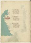
¶ Quata Alexandria per ponente setta E guata a tramontana Satalia E terra richa nobil e perfecta E de gran porto di mercadantia Da indi e focie ove il nillo in mar getta Cinquanta miglia sum per drita via E chiamasi Ivi il fiume del rosseto Che sum trea millia miglia dal strecto
¶ Un’altra foce sença fare girata Piu su cinquanta miglia al mar dichina Passato quello trovi damiata Poi sum ducento miglia di marina Fin a larissa che -e- la piu ingolfata Che piu al mar rosso s’avicina E quivi da levante a tramontana Il lito gira e tuta terra piana
¶ Da larissa a laiaça d’ermenia Rita costiera sum miglia seicento Per tramontana tuta quella via In verso greco per quarta di vento Il porto di baruti di soria Nel meço sta a puocco a le trecento E quindi sono a ch'il pilglia Fino Alexandria cinquecento miglia
[image, right margin and lower margin: Map depicting a stretch of the Egyptian coast. Ocean painted aquamarine with wave pattern in grey. At ¶ 2: on a tributary extending rightwards sits a fortified city; above it, in red ink: (label: CHAIRO .); below it, in red ink: (label: chairo de babilonia). The city, tinted reddish-brown with blue roofs, includes a tower with a blue-and-white-striped dome from which flies a flag, yellow with crenelated edge, bearing: Escutcheon Azure overall a Moor’s head proper, couped, blindfolded Argent. At the mouth of the tributary, two islands: one outlined with a reddish-pink wash; the other painted blue with a white diamond marked /d/ in red ink, the remainder of its name—(label: damiata)—continuing on the nearby coast. Location names along the coastline, top to bottom, in red ink: (label: Larissa), (label: Rosseto), (label: alexandria), (label: Lucho).]