Pages That Mention tripoli
Kenneth Spencer Research Library, Pryce MS P4 Place Names Identified

Page 41
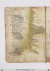
P. 41 Guide letter: d] [D]Affrica ad capulia et ad faciesse Son molte secche dallito rimote E che vol navichare indi ad capessie Fra esse ellito per canal si puote Et seguon poi fine ad rasamabesse Ma qui bisognia che di fuori si rote Da tunisi insin qui per maestraele Trecento miglia son per diricto strale [Guide letter: p] [P]oi tripoli cicta di barbaria Centovinticinque verlevante E misurata fu per quella via Duciento miglia et due volte altre tante Fo et sonno fino ad rauseni per traversa Dove fa un capo il monte achalante Lasciando uno golfo ove ad man dricta Çamara et poi bernicho et tholomecta [Guide letter: e] [E]chi girasse il golfo per costea Barrebon piu delle miglia duciento Dal capo di rausem abon andrea Son ciento miglia pur per drecto vento Lucho piu su duciento par che stea Indi Allexandria aquactro ciento Che quasi in mezo dessa sta larassa Et e/ questo paese terra bassa
Right margin, a portolan-style map drawn in brown ink and oriented with East at the top representing, counterclockwise starting at the top: 1) the western tip of Sicily (label: cecilia) colored red; 2) the southern tip of Sardinia (label: sardenga), with land coastline lightly shaded brown; and 3) the northern coast of Tunisia and Algeria, the seacoast lightly shaded in green, and with the following places labeled, from the top and counterclockwise down the coast: Africa (label: affrica), [Gabes?] (label: Papae), Cape Bon/Ras ed-Dar (label: capo bono), Tunis (label: tunigi.), Bizerte (label: biserta.), Tabarka (label: tabarta.), Annaba (label: bona.), Stora (label: storia.), [?] (label: angolo.), [?] (label: zizari.), Béjaïa (label: bugea.), Dellys (label: titelis), Algiers (label: algeri).

Page 42
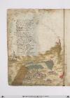
P. 42 Socto Alexandria per ponente secta Eguata atramontana satalia E terra richa nobile et perfecta Et e/ gran porto di marchatantia Da indi afocie ovel nilo inmar giecta Cinquanta miglia son perricta via Et chiamasi ivi il fiume di rosecto Et sonno tre milia miglia dallo strecto Unaltra focie sança far girata Piu su cinquanta miglia al mar di china Passata quella truovi damiata Poi son ducento miglia di marina Fin alla rissa che la pur ingolfata Che piu al mar rosso sa vicina Equivi dalevante a tramontana Illito gira e tucte terra piana Dalla rissa alla iaçça darmenia Ricta costiera son miglia seycento Per tramontana tucta quella via Va verso greco per quarta di vento Il porto di baruti di soria Nel meço sta puncto di trecento Equindi sono archi il pileggio piglia Fino allexandria cinquecento miglia
[Image: Left margin, a continuation from fol. 21r of the coastal portolan-style map of Tunisia, oriented with east at the top, drawn in brown ink with the coast shaded in green. The following place names are labeled from east to west (top to bottom): [?] (label: luco), Bon-Andrea [or Apollonia?] (label: bonandrea.), [?] (label: capo dirausor), Tolmeta (label: tolometta.), Berenice (label: bernico), [?] (label: zunara), Misratah (label: misurata.), Tripoli (label: tripoli), [?] (label: rasamabesse), [?] (label: capesse), [?] (label: facesse), [?] (label: capulia), Tunis (label: tunisi), ending with Africa (label: africa).

Page 44
P. 44 Da baruti infra terra una giornata E una mezza equel gran cictade Chentucto il mondo e tanto nominata Mercatantesta e/ di gran nobilitade Possente e/ riccha damasco chiamata Che neuna di magior antiquitade Sovra la terra non trovan che sia Et e/ stata gran facto tucta via Tripoli di soria]] segue per mare Sexanta miglia e poi trenta tortosa Laleccha poi septanta inquellandare Et tucta questa e/ terra montuosa fin poi cinquanta miglia dove appare La focie di soldino assai famosa poi elaxandria altre cinquanta E insino alla raçça poi quaranta Anguli cento fa qui la marina E voglie molti venti e ad ponente Verso libeccio a quaranta sidichina Fin ad antrochecta oquasi mente La iazza aciento miglia sa vicina Atarso e/ poi quaranta le seguente Il turcho e poi palopoli a septanta Et adantrochecta a poi novanta
[Image: Lower margin, a map of the Middle East, oriented with North at the top, extends from İskenderun to the Red Sea, drawn in brown ink. The River Jordan (label: fiume jordano) (colored green) flows from a range of hills (colored grey-brown) and connects the Sea of Galilea (label: mar de galilea) and the [Dead Sea?] (label: lago de sodoma). At the upper left Damascus (label: damasco.) appears as a group of 11 towers within a city wall. At the bottom center are Jerusalem (label: jerusalem), a cluster of 3 domes surrounded by 7 towers and a city wall and nearby Mout Zion (label: sion). The only other structure is the monastery of Saint Catherine (label: sancta k[a]tarina.) on Mount Sinai (label: monte sinai) at the far right. Other inland towns named are: Nazareth (label: nazaret) and Bethlehem (label: betelem). Regional place names are: Galilee (label: galilea), Samaria (label: samaria) and Judea (label: iudea). At the bottom of the page, the Mediterranean coast features the following ports, from north to south (left to right): İskenderun (label: alexandretta), [?] (label: soldino.), [Latakia/Laodiceia?] (label: la lecha.), Tartus (label: tortosa), Tripoli (label: Tripoli.), Beirut (label: baruti.), Sarepta/Zarephath (label: Saretta.), Acre (label: acri.), Caesarea (label: cesaria), Joppa (label: joppon.), Ashkelon (label: arsalona.), Gaza (label: gaza), and [El Arish?] (label: larissa).]
Vat.lat.7612 Place names identified
20v
P. 40 Daafricha achapulia eadfaciesse sonmolte secche dallito remote echivole navichare indi achapesse fraesse ellito perchanale sipuote eseghuon poy fino atrasamabesse maqui bisongna chedifuori sirote datunisi insiqui per maestrale treciento miglia sono perdiritto strale
Poy tripoli citta dibarberia cientoventicinque miglia inverlevante emisurata superquella via dugiento miglia eduo volte altretante sonfino adrausen pertraversia [corr. pertraverso?] dove fa unchapo ilgram monte tatalante lascciando ungholfo dove e daman diretta zunaro epoi berniccho etolometta
Echi girasse ilgholfo perchostea sarebonpiu dellemiglia dugiento dalchapo dirausen abonondrea sonciento miglia opiu perdetto vento lungho piusu dugiento parchestia eindi adalisandria aquatrociento chequasi imezzo desse sta larassa edequesto paese terra bassa
[Image: Right and lower margins, a map showing the continuation of the North African coastline, top to bottom / east to west: (label: lucho), (label: Bonandrea), (label: Tolometta), (label: Bernicho), (label: Misim?), to (label: Tripoli) with a small image of a walled city, (label: Rasamatis), (label: Capisse) at the end of an inlet or bay, and (label: Capo bona), with a detailed illustration of a large walled city that looks much like Renaissance Florence.]
21v
P. 42 Larissa aintorno stangni ealmargialle en fraterra diserti infino alocho dove latrista ebene punita valle chegiudichata fu daddio colfocho quive unlagho morto epoi lespalle delmonte sinai piula sonpocho Sulquale fu data laleggie divina dove sepulto santa chaterina
Trallarissa abaruti apunto ymedio eiopeni porto dallaterra santa chedicholui doverebbesser perdio chechapo decristiani essere sivanta dove queldengno re tenne suo sedio chefecie lopra chongni disighanta dove il santo sepulcro dy yhesu ladove crucifisso pernoi fu
Sion equesto chapo dy Judea verso levante unpocho adestra mano edasinistra mano eghalilea edallavante sta ilfiume giordano edaman dritta seghue cresarea eacri esur esaretta ellibano monte dondecie ilfiume diduofonti quive charmegli ealtri santi monti
[Image: Lower margin, a mountainous coastline from Damascus to St. Catherine's monastery on Mt. Sinai, with the inland Sea of Galilee and a burning, unlabeled city on its shore and Jerusalem, among smaller cities, in the foreground. Between Damascus (label: Domasco) and St. Catherine's (label: sancta katerina), a ridge of mountains labeled (label: monte libano), (label: monte darabia), and (label: Monte sinai). Below them, (label: Mare digalilea) with inlets or rivers labeled (label: dan) and (label: Tor). Along the Levantine coast at the bottom of the page, left to right / north to south: (label: Soldino), (label: Tripoli), (label: baruti), (label: Sarata), (label: Surs), (label: Acri), (label: Cesarea), (label: Gerusalem), (label: Iope), (label: Ascalona), (label: chaza). Above the last of these, (label: Mar rosso), colored red.