Pages
THE CHARTOGRAPHY OF NEW ZEALAND. 7
Dashwood and Mitchell's tour from Nelson to Lyttelton, along with a small map, appeared in the volume for 1851. J.T. Thompson's account and map of what is now the Province of Southland in the volume for 1858. E. Stanford published in London, in the year 1856, a map of the Province of Canterbury, showing freehold sections and pasturage runs; scale, 1:220.000. J. Arrowsmith published two editions of his map of New Zealand on a scale of 1:2.400.000 - one dated July, 1851, the other, July, 1858.
With the explorations and surveys of F. v. Hochstetter and J. Haast (which were commenced in 1859, and are still unfinished), began a new epoch in the geographical knowledge and chartography of New Zealand.* Not only have their labours enlarged the existing knowledge, but they have thrown quite a new light on the geological and topographical condition of the interior, as hitherto the topographical configuration of the country has been much neglected by the colonial surveys. The general map of this work (Map I.), in the completion of which Hochstetter's and Haast's observations have been used for the first time, will show at the first glance how much our former conception of New Zealand is enlarged and corrected. Of course, on it the observations of many others also have been recorded.
The progress of the chartography of New Zealand is best shown in the various editions of Arrowsmith's maps, of which there are three - 1841, 1851, and 1858 - which were compiled from official and other documents existing at those times. The edition of 1841 contains nothing but a coast line, and this very imperfect - here and there an error of half a degree; in the interior are only a few roughly noted lakes, rivers, and mountains. In the edition of 1851 the coast, if yet incomplete, is corrected after the marine surveys, and the interior is filled up. But the edition of 1858 contains many additions _________________________________________________________ * A report by Dr. J. Haast, Geologist of the Province of Canterbury, dated 3rd of March, 1863, describes his latest travels and surveys of the Southern Alps. This traveller had penetrated into the upper region of the Molyneaux River, with its magnificent lakes Wanaka and Hawea, to the West Coast, and discovered a pass through the chain of Alps at an elevation of only 1,612 feet, between the Wanaka Lake and the Awarua River.
8 THE GEOLOGY OF AUCKLAND
of importance. The most complete map published before ours appeared in the Despatch Atlas, March, 1861, in two sheets, and at a scale of 1:1.900.000 and 1:2.300.000.
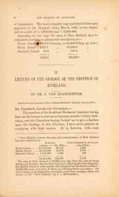
According to our map the area of New Zealand may be estimated according to planimetric calculation, at -
North Island ... 2041∙6 German, or 43,400∙9 Eng. sq. miles. South Island ... 2627∙7 " 55,860∙3 " Stewart's Island 33∙3 " 707∙8 " ______ _______ 4702∙6 99.969 * ~~~~~~~~~~~~~~~~~~~~~~~~~~~
II. LECTURE ON THE GEOLOGY OF THE PROVINCE OF AUCKLAND. ___________ BY DR. F. VON HOCHSTETTER. ___________ [delivered to the Members of the Ackland Mechanics' Institute, June 24, 1859.]
Mr President, Ladies and Gentlemen, -
The members of the Auckland Mechanics' Institute having done me the honour to elect me as honorary member of their institution, and the Committee having invited me to give a Lecture upon the Geology of this Province, I have much pleasure in complying with their request. It is, however, with some _____________________________________________________________ *From English sources the area and circumference of New Zealand has been estimated at - Surface Circumference of Coast. Acres Sq. Mls. Sea Miles North Island ... ... 31,174,400 48,710 1,500 Middle Island . ... 46,126,860 72,072 1,500 Stewart's Island .. 1,152,000 1,800 120 _________ _____ _____ 78,452,480 122,582 3,120 The area of New Zealand is 50,000 acres less than the area of Great Britain and Ireland; the Northern Island is 1-32nd smaller than England; the Middle Island is 1-9th smaller than England and Scotland combined; 50,000,000 acres or 2-3rds, of which are estimated fit for agriculture; the rest is made up of impassable mountains, sand-flats, swamps, lakes, and rivers. - (Vide "New Zealand," by J. v. Hochstetter.)
THE GEOLOGY OF AUCKLAND. 9
hesitation that I undertake this task, feeling that my imperfect knowledge of the English language will prevent my making the short sketch I wish to lay before you as interesting as it might otherwise have been. Notwithstanding this drawback, I am glad to have this opportunity of giving the inhabitants of this Province, through the members of this Institute, such a résumé as I can of the chief results of the Geological Survey I have made of those parts of the country I have visited.
I feel this, indeed, to be a duty I owe to the community at large, in return for the very kind reception that has everywhere been given me - for the ready help that has always been afforded by all whom I have met with - and for the interest that has been shown by all in the proceedings of the Imperial Austrian "Novara" Expedition.
Having, in the months of January and February completed my Survey, and finished a Geological Map, of the Auckland District - which I now have the pleasure of showing you - the necessity arose for my choosing either the Northern or the Southern portion of the Province for my further researches, my limited stay in New Zealand rendering it impossible for me to make a sufficient examination in both directions.
I did not hesitate to choose the Southern districts - for these reasons : that the country over which I should there proceed, is inhabited almost exclusively by Maoris, and has hitherto been almost unknown and totaly unsurveyed, both topographically and geologically. The Northern districts, on the contrary, are of the most part better known, and from the number of European settlers in them, I was led to hope I should be enabled to collect some information through specimens forwarded to me for examination, and from the verbal descriptions of those who are well acquainted with the various localities.
My hope was not unfounded in either respect.
I have received many specimens of interest from various localities; also some valuable information from different settlers, and especially from my friends, the Rev. A.G. Purchas and Mr. C. Heaphy, who in the last few months have had opportunities of visiting several parts of the Northern portion of this Province, and of collecting very valuable specimens. In addition to this must be remembered the fact, that other scientific men, especi-
10 THE GEOLOGY OF AUCKLAN.
ally MM. Dieffenbach and Dana, had already visited and described at length some parts of the Northern country.
Through the liberality and excellent arrangements of the General and Provincial Governments, I have been enabled in a comparatively short time to travel over and to examine the larger portion of the Province South of Auckland, extending as far as Lake Taupo and Tongariro Volcano, the boundaries between this Province and those of Wellington and Hawke's Bay. I have thus obtained materials which will enable me, on my return to Europe, to construct a Topographical and Geological Map of the central part of the Northern Island.
My observations have, with the able assistance of Mr. Drummond Hay, extended from the East to the West Coast; and the numerous peaks and ranges have afforded facilities for fixing with satisfactory accuracy, by means of magnetic bearings, on the basis of points previously fixed by the nautical survey of Capt. Drury on the coast-line, all the great natural features of this portion of the country. A great number of barometrical observations have afforded me the means of ascertaining the heights of mountains and plains in the interior, which I shall be able to calculate with accuracy by the aid of corresponding daily observations, taken in Auckland by Colonel Mould, who has kindly forwarded me a copy of his tables.
I have also obtained photographic and other views of great interest, many of which were taken by the gentlemen who accompanied me on the expedition for this purpose; and a large number of exceedingly valuable sketches have been contributed by the talented pencil of our president, Mr. C. Heaphy, for future publication in a geological atlas. Many of these are decorating the walls and others are lying on the table, and I shall be happy to show them to any ladies and gentlemen who may feel any interest in seeing them, at the conclusion of this lecture.
My collections have been growing from day to day, and include specimens of great interest in most branches of Natural History. I owe a great deal to the indefatigable zeal of my friend and fellow-traveller, Mr. J. Haast, who assisted me in collecting during our expedition. I am also much indebted to Mr. J. Crawford at Wellington, Mr A.S. Atkinson of Taranaki, Mr. Triphook of Hawke's Bay, Mr H.T. Kemp of the
THE GEOLOGY OF AUCKLAND. 11
Bay of Islands, to the Missionaries, and to almost innumerable friends in Auckland.
PRELIMINARY REMARKS. I cannot suppose that all my audience are acquainted with the first principles of Geology. I shall therefore be under the necessity, in order to make my report intelligible, of prefacing a few remarks upon the chief divisions of the geological formations.
The vaious rocks, soils, and minerals which occur upon the surface of the earth, or at various depths beneath it - in one word, the materials of the "earth's crust" - are classified, in the first place, with reference to their different origin, or, in other words, with reference to the different circumstances and causes by which they have been produced. They are divided into four great classes - Plutonic, Metamorphic, Aqueous, and Volcanic rocks. Another mode of classification is with reference to their age - that is, to the comparative periods of their formation. Those divisions will be easily understood.
The plutonic rocks comprehend all the granites, syenites, porphyries, diorites - rocks which agree in being highly crystalline, unstratified, and destitute of organic remains - which are considered as of igneous origin, formed in the earliest periods of the earth, in great depths, and cooled and crystalised slowly under great pressure.
The Metamorphic rocks are the crystalline strata, or schists, called gneiss, mica-schist, or mica-slate, chlorite-schist, hornblende-schist- also destitute of organic remains. According to the most probable theory, these strata were originally deposited from water in the usual form of sediment, but were subsequently altered by subterranean heat, so as to assume a new texture.
The two first classes of rocks are usually found in such a position that they form the foundation on which the aqueous rocks were afterwards superimposed. For instance, they compose the central line or a range of mountains, on both sides of which sedimentary rocks are deposited. Thus, in reference to their age, they are considered as the oldest, and are therefore called also Primitive.
There are exceptions to this rule in reference to the age of
